IMAGES TAKEN NEAR TO
Cwmbelan, LLANIDLOES, SY18 6QD
Introduction
This page details the photographs taken nearby to SY18 6QD by members of the Geograph project.
The Geograph project started in 2005 with the aim of publishing, organising and preserving representative images for every square kilometre of Great Britain, Ireland and the Isle of Man.

There are currently over 7.5m images from over14,400 individuals and you can help contribute to the project by visiting https://www.geograph.org.uk
Image Map
Images are licensed for reuse under creativecommons.org/licenses/by-sa/2.0
Notes
- Clicking on the map will re-center to the selected point.
- The higher the marker number, the further away the image location is from the centre of the postcode.
Image Listing (5 Images Found)
Images are licensed for reuse under creativecommons.org/licenses/by-sa/2.0
Image
Details
Distance
1
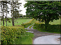
Bridleway to Cefn farm
The first bit of the bridleway shares the lane to Ty'n-y-dderw farm.
Image: © Nigel Brown
Taken: 31 May 2011
0.14 miles
2
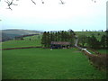
An old barn
With the valley of the Afon Dulas to the left.
Image: © David Medcalf
Taken: 16 Mar 2007
0.15 miles
3
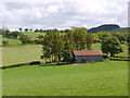
Barn amongst the fields
A large, weathered structure, with corrugated iron roof and wooden walls.
Image: © Nigel Brown
Taken: 31 May 2011
0.16 miles
4
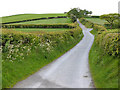
Road heading up Bryn Mawr
Executing a dog-leg as it reaches the watershed.
Image: © Nigel Brown
Taken: 31 May 2011
0.21 miles
5
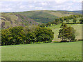
View towards the Dulas valley
Looking over fields to the Tylwch gorge, with Craig Tylwch on the left.
Image: © Nigel Brown
Taken: 31 May 2011
0.23 miles