IMAGES TAKEN NEAR TO
Van, LLANIDLOES, SY18 6NZ
Introduction
This page details the photographs taken nearby to SY18 6NZ by members of the Geograph project.
The Geograph project started in 2005 with the aim of publishing, organising and preserving representative images for every square kilometre of Great Britain, Ireland and the Isle of Man.

There are currently over 7.5m images from over14,400 individuals and you can help contribute to the project by visiting https://www.geograph.org.uk
Image Map
Images are licensed for reuse under creativecommons.org/licenses/by-sa/2.0
Notes
- Clicking on the map will re-center to the selected point.
- The higher the marker number, the further away the image location is from the centre of the postcode.
Image Listing (13 Images Found)
Images are licensed for reuse under creativecommons.org/licenses/by-sa/2.0
Image
Details
Distance
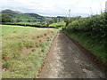
1
Lower Ty'n-y-fron
Image: © Stephen Whittaker and Katharine Oakeshott
Taken: 20 Aug 2007
0.01 miles
2
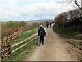
Lower Tyn y Fron Isaf
Cerddwyr yn mynd heibio i'r mynediad i Dyn y Fron Isaf.
Walkers passing the entrance to Lower Tyn y Fron (trans. hillside homestead).
Image: © Alan Richards
Taken: 24 Apr 2016
0.02 miles
3
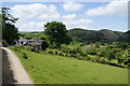
Lower Ty'n-y-fron Farm
With views over to the Clywedog Dam on the right.
Image: © Bill Boaden
Taken: 19 May 2011
0.04 miles
4
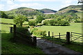
Gated road in the Clywedog valley
The Clywedog Dam is straight ahead, keeping the water at a much higher level than this valley.
Image: © Bill Boaden
Taken: 19 May 2011
0.07 miles
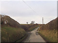
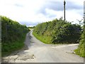
5
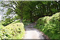
Gated road below Ty'n-y-fron
This road links both sides of the Afon Clywedog valley, and it would be a long drive round without it.
Image: © Bill Boaden
Taken: 19 May 2011
0.07 miles
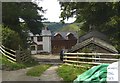
6
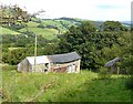
Buildings belonging to Upper Ty'n-y-fron farm
Image: © Stephen Whittaker and Katharine Oakeshott
Taken: 20 Aug 2007
0.11 miles
7
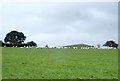
Rounding up sheep with a quad-bike
No longer a shepherd with his crook, but the faithful sheepdog is there somewhere
Image: © Eirian Evans
Taken: 24 Aug 2020
0.13 miles
8
The road leading WNW from Glan-y-nant towards Bryn Mawr
The road on the right leads to Upper and Lower Ty'n-y-fron and Cwm Deildre
Image: © Stephen Whittaker and Katharine Oakeshott
Taken: 20 Aug 2007
0.13 miles