IMAGES TAKEN NEAR TO
Old Hall, LLANIDLOES, SY18 6NY
Introduction
This page details the photographs taken nearby to SY18 6NY by members of the Geograph project.
The Geograph project started in 2005 with the aim of publishing, organising and preserving representative images for every square kilometre of Great Britain, Ireland and the Isle of Man.

There are currently over 7.5m images from over14,400 individuals and you can help contribute to the project by visiting https://www.geograph.org.uk
Image Map
Images are licensed for reuse under creativecommons.org/licenses/by-sa/2.0
Notes
- Clicking on the map will re-center to the selected point.
- The higher the marker number, the further away the image location is from the centre of the postcode.
Image Listing (3 Images Found)
Images are licensed for reuse under creativecommons.org/licenses/by-sa/2.0
Image
Details
Distance
1
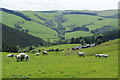
Brithdir above the Hafren valley
Viewed from the Maenhinon road, where the view suddenly opens up like this.
Image: © Bill Boaden
Taken: 19 May 2011
0.01 miles
2
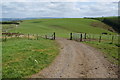
Track and bridleway above Maenhinon
Maenhinon is the lump ahead, forming the ridge between the valleys of the Hafren and Clywedog. The track and bridleway diverge behind me, but it appears that most users follow the track.
Image: © Bill Boaden
Taken: 19 May 2011
0.24 miles
3
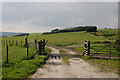
Diverging bridleways
One branches to the right and up the hill, eventually reaching the Hafren forest; that's if you can pass the intimidating-looking herd of cattle currently occupying its path. The other branches left, following the track down to Brithdir farm.
Image: © Nigel Brown
Taken: 18 Sep 2008
0.25 miles