IMAGES TAKEN NEAR TO
Van, LLANIDLOES, SY18 6NR
Introduction
This page details the photographs taken nearby to SY18 6NR by members of the Geograph project.
The Geograph project started in 2005 with the aim of publishing, organising and preserving representative images for every square kilometre of Great Britain, Ireland and the Isle of Man.

There are currently over 7.5m images from over14,400 individuals and you can help contribute to the project by visiting https://www.geograph.org.uk
Image Map
Images are licensed for reuse under creativecommons.org/licenses/by-sa/2.0
Notes
- Clicking on the map will re-center to the selected point.
- The higher the marker number, the further away the image location is from the centre of the postcode.
Image Listing (8 Images Found)
Images are licensed for reuse under creativecommons.org/licenses/by-sa/2.0
Image
Details
Distance
1

Pwll Yr Ebol
Old mine level and Pwll Yr Ebol Cottage looking south
Image: © William Pugh
Taken: 21 Oct 2007
0.09 miles
2
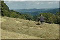
Enjoying the view near Van Road
Having used a very old tractor to cut the hay, a bit of old fashioned manual labour was required to get the hay "in line" prior to baling.
Image: © William Pugh
Taken: 12 Aug 2010
0.11 miles
3

Farmland by Pen-y-Castell
An area of great historic interest, with the Pen-y-castell hill fort dominating, but there are also several old mine workings in the vicinity.
Image: © John Lucas
Taken: 16 Dec 2006
0.16 miles
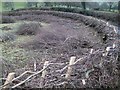
4

Old mine level at Pwll-yr-ebol
Part of the extensive mine workings that are to be found in this area.
Image: © John Lucas
Taken: 16 Dec 2006
0.16 miles
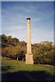
5

Beech Tree at Pen-y-Castell
Just below the ancient hill-fort that dominates the area.
Image: © John Lucas
Taken: 16 Dec 2006
0.16 miles
6
New hedging on Van Road
Fresh hedging on a very tight bend in the road.
Image: © William Pugh
Taken: 17 Jan 2011
0.18 miles
8
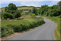
Road heading away from Van
The northern outlet from the village. Bryn y Fan, the hill which gives the village its name, can be seen ahead.
Image: © Nigel Brown
Taken: 3 Jul 2010
0.19 miles