IMAGES TAKEN NEAR TO
Van, LLANIDLOES, SY18 6NQ
Introduction
This page details the photographs taken nearby to SY18 6NQ by members of the Geograph project.
The Geograph project started in 2005 with the aim of publishing, organising and preserving representative images for every square kilometre of Great Britain, Ireland and the Isle of Man.

There are currently over 7.5m images from over14,400 individuals and you can help contribute to the project by visiting https://www.geograph.org.uk
Image Map
Images are licensed for reuse under creativecommons.org/licenses/by-sa/2.0
Notes
- Clicking on the map will re-center to the selected point.
- The higher the marker number, the further away the image location is from the centre of the postcode.
Image Listing (4 Images Found)
Images are licensed for reuse under creativecommons.org/licenses/by-sa/2.0
Image
Details
Distance
2
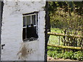
Scene at Bron-y-geifr farm from Glyndwr's Way
This young bovine seems to be enjoying the experience of sticking its head out of the window here. Eyecatching to passing walkers.
Image: © Jeremy Bolwell
Taken: 13 Apr 2014
0.09 miles
3
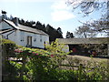
Bron-y-geifr farm
An immaculate old farm house and yard here. We chatted to the farmer's wife who was interesting and interested.
Image: © Jeremy Bolwell
Taken: 13 Apr 2014
0.09 miles
4
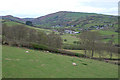
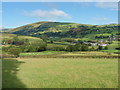
Field above Cwm-ystordy farm
Steep grazing land. The old mining village of Y Fan (Van) can be seen in the distance.
Image: © Nigel Brown
Taken: 28 Apr 2010
0.11 miles