IMAGES TAKEN NEAR TO
Van, LLANIDLOES, SY18 6NN
Introduction
This page details the photographs taken nearby to SY18 6NN by members of the Geograph project.
The Geograph project started in 2005 with the aim of publishing, organising and preserving representative images for every square kilometre of Great Britain, Ireland and the Isle of Man.

There are currently over 7.5m images from over14,400 individuals and you can help contribute to the project by visiting https://www.geograph.org.uk
Image Map
Images are licensed for reuse under creativecommons.org/licenses/by-sa/2.0
Notes
- Clicking on the map will re-center to the selected point.
- The higher the marker number, the further away the image location is from the centre of the postcode.
Image Listing (5 Images Found)
Images are licensed for reuse under creativecommons.org/licenses/by-sa/2.0
Image
Details
Distance
1
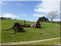
Old agricultural implements beside Glyndwr's Way
A not uncommon sight on many farms everywhere, a few old bits of outdated machinery just left beside the path here, their scrap value never realised and instead they have been a rubbing post for countless generations of sheep.
Image: © Jeremy Bolwell
Taken: 13 Apr 2014
0.10 miles
2
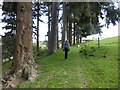
On Glyndwr's Way in spring
It's at its best in the early spring.
Image: © Jeremy Bolwell
Taken: 13 Apr 2014
0.15 miles
3
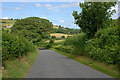
The Van road
Southern approach to the village from Llanidloes.
Image: © Nigel Brown
Taken: 3 Jul 2010
0.19 miles
4
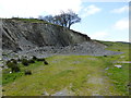
Old quarry beside Glyndwr's Way
A source of stone for tracks and pothole filling I assume.
Image: © Jeremy Bolwell
Taken: 13 Apr 2014
0.21 miles
5
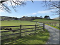
Glyndwr's Way near Van
Nice farm drive here.
Image: © Jeremy Bolwell
Taken: 13 Apr 2014
0.23 miles