IMAGES TAKEN NEAR TO
Oakley Park, LLANIDLOES, SY18 6LT
Introduction
This page details the photographs taken nearby to SY18 6LT by members of the Geograph project.
The Geograph project started in 2005 with the aim of publishing, organising and preserving representative images for every square kilometre of Great Britain, Ireland and the Isle of Man.

There are currently over 7.5m images from over14,400 individuals and you can help contribute to the project by visiting https://www.geograph.org.uk
Image Map
Images are licensed for reuse under creativecommons.org/licenses/by-sa/2.0
Notes
- Clicking on the map will re-center to the selected point.
- The higher the marker number, the further away the image location is from the centre of the postcode.
Image Listing (5 Images Found)
Images are licensed for reuse under creativecommons.org/licenses/by-sa/2.0
Image
Details
Distance
1
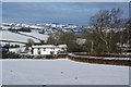
Dol-llys Fach
Farmhouse above the valley of Singen Brook.
Image: © Bill Boaden
Taken: 15 Jan 2013
0.01 miles
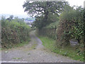
3
Cyffwrdd Ffordd ger Cefn Bach / Road Junction near Cefn Bach
Cyffwrdd Ffordd ar Lwybyr Beicio Sustrans 81 / Road Junction on Sustrans Cycle Route 81
Image: © Ian Medcalf
Taken: 2 Apr 2007
0.11 miles
4
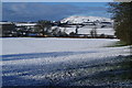
Field above Cefnmawr
The farm is visible in the trees. The skyline is dominated by Bryn y Fan which overlooks Llyn Clywedog on the other side of it.
Image: © Bill Boaden
Taken: 15 Jan 2013
0.17 miles
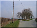
5
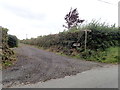
Farm track to Cefn Mawr
Also a junction on the Severn Way, a long distance walking route which follows the River Severn downstream from source to sea.
Image: © Eirian Evans
Taken: 23 Aug 2020
0.20 miles