IMAGES TAKEN NEAR TO
Newchapel, LLANIDLOES, SY18 6JY
Introduction
This page details the photographs taken nearby to SY18 6JY by members of the Geograph project.
The Geograph project started in 2005 with the aim of publishing, organising and preserving representative images for every square kilometre of Great Britain, Ireland and the Isle of Man.

There are currently over 7.5m images from over14,400 individuals and you can help contribute to the project by visiting https://www.geograph.org.uk
Image Map
Images are licensed for reuse under creativecommons.org/licenses/by-sa/2.0
Notes
- Clicking on the map will re-center to the selected point.
- The higher the marker number, the further away the image location is from the centre of the postcode.
Image Listing (4 Images Found)
Images are licensed for reuse under creativecommons.org/licenses/by-sa/2.0
Image
Details
Distance
1
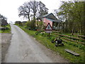
Cottage beside Glyndwr's Way above Newchapel
A lovely remote cottage high in the hills.
Image: © Jeremy Bolwell
Taken: 19 Apr 2014
0.00 miles
2
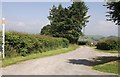
Entrance to Tyndrain
South of Newchapel. The farm name was Tyddyn y Drain then Tyn-y-Drain then Tyndrain as it is currently known now.
Image: © John Firth
Taken: 9 Jul 2013
0.10 miles
3
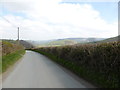
Lane on Glyndwr's Way near Newchapel
Big skies above GW.
Image: © Jeremy Bolwell
Taken: 19 Apr 2014
0.12 miles
4
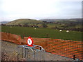
Farmland near Ashfield farm
The farm is hidden below the crest of the slope. The device in the foreground [made more vivid by the camera flash] appears to be for weighing sheep.
Image: © David Medcalf
Taken: 16 Mar 2007
0.24 miles