IMAGES TAKEN NEAR TO
Llidiartywaun, LLANIDLOES, SY18 6JT
Introduction
This page details the photographs taken nearby to SY18 6JT by members of the Geograph project.
The Geograph project started in 2005 with the aim of publishing, organising and preserving representative images for every square kilometre of Great Britain, Ireland and the Isle of Man.

There are currently over 7.5m images from over14,400 individuals and you can help contribute to the project by visiting https://www.geograph.org.uk
Image Map
Images are licensed for reuse under creativecommons.org/licenses/by-sa/2.0
Notes
- Clicking on the map will re-center to the selected point.
- The higher the marker number, the further away the image location is from the centre of the postcode.
Image Listing (6 Images Found)
Images are licensed for reuse under creativecommons.org/licenses/by-sa/2.0
Image
Details
Distance
2
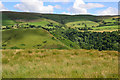
View across the Nant Feinion valley
With windfarm-topped Pegwn Mawr rising beyond.
Image: © Nigel Brown
Taken: 30 Jul 2012
0.03 miles
3
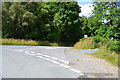
Road junction in Llidiartywaun
Where a minor road leads off to give access to a couple of farms.
Image: © Nigel Brown
Taken: 30 Jul 2012
0.03 miles
4
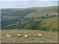
Grazing above the Nant Feinion valley
Sheep grazing near the lane corner, seen in early evening light. The wind farm is not nearly as distractingly unsightly on the photo as it is in real life.
Image: © Andrew Hill
Taken: 31 Jul 2014
0.05 miles
5
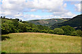
Field in Llidiartywaun
Lying above the Nant Feinion valley, with woodland beyond.
Image: © Nigel Brown
Taken: 30 Jul 2012
0.06 miles
6
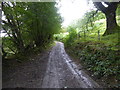
On part of Glyndwrs Way
A steep lane after an even steeper field climb - tiring!
Image: © Jeremy Bolwell
Taken: 29 Sep 2019
0.24 miles