IMAGES TAKEN NEAR TO
Llys Clywedog, LLANIDLOES, SY18 6HW
Introduction
This page details the photographs taken nearby to Llys Clywedog, SY18 6HW by members of the Geograph project.
The Geograph project started in 2005 with the aim of publishing, organising and preserving representative images for every square kilometre of Great Britain, Ireland and the Isle of Man.

There are currently over 7.5m images from over14,400 individuals and you can help contribute to the project by visiting https://www.geograph.org.uk
Image Map
Images are licensed for reuse under creativecommons.org/licenses/by-sa/2.0
Notes
- Clicking on the map will re-center to the selected point.
- The higher the marker number, the further away the image location is from the centre of the postcode.
Image Listing (191 Images Found)
Images are licensed for reuse under creativecommons.org/licenses/by-sa/2.0
Image
Details
Distance
2
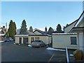
Llanidloes Hospital
A view east from the small car park by the outpatients clinic entrance.
Plenty of snow on Gorn Hill in the background.
Image: © Penny Mayes
Taken: 24 Jan 2013
0.08 miles
3
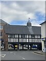
Market hall, Llanidloes
17th century timbered hall - a Grade I listed building.
Image: © Alan Hughes
Taken: 12 Oct 2021
0.09 miles
4
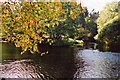
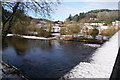
Junction of River Severn with Afon Clywedog
The River Severn flows out of Llanidloes from the left. Towards us flows the Afon Clywedog, a significant river in its own right, but whose flow is controlled by the Clywedog Dam and Reservoir 4 miles upstream.
Image: © Graham Horn
Taken: 18 Oct 2003
0.09 miles
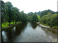
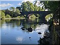
5
The River Severn at Llanidloes
Viewed from the Long Bridge which carries the B4518.
Image: © Bill Boaden
Taken: 15 Jan 2013
0.09 miles
7
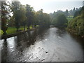
Part of the River Severn at Llanidloes
Viewed from the 1930's bridge.
Image: © Jeremy Bolwell
Taken: 10 Oct 2010
0.09 miles
8

Ordnance Survey Cut Mark
This OS cut mark can be found on the SW parapet of the Long Bridge. It marks a point 165.242m above mean sea level.
Image: © Adrian Dust
Taken: 13 Sep 2023
0.09 miles
9
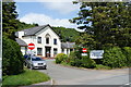
Llanidloes & District War Memorial Hospital
This offers outpatient, physio, maternity and geriatric services, but is under threat of closure.
Image: © Bill Boaden
Taken: 19 May 2011
0.10 miles
10
Long Bridge and the River Severn (Llanidloes)
Built in 1826 by Thomas Penson and widened in 1938 on the upstream side, this stone bridge spans the River Severn, and this is the first town the River Severn passes through. This replaced a timber bridge from 1741, and this bridge carries the B4518 road.
Image: © Fabian Musto
Taken: 4 Jun 2021
0.10 miles