IMAGES TAKEN NEAR TO
Van Road, LLANIDLOES, SY18 6HB
Introduction
This page details the photographs taken nearby to Van Road, SY18 6HB by members of the Geograph project.
The Geograph project started in 2005 with the aim of publishing, organising and preserving representative images for every square kilometre of Great Britain, Ireland and the Isle of Man.

There are currently over 7.5m images from over14,400 individuals and you can help contribute to the project by visiting https://www.geograph.org.uk
Image Map
Images are licensed for reuse under creativecommons.org/licenses/by-sa/2.0
Notes
- Clicking on the map will re-center to the selected point.
- The higher the marker number, the further away the image location is from the centre of the postcode.
Image Listing (3 Images Found)
Images are licensed for reuse under creativecommons.org/licenses/by-sa/2.0
Image
Details
Distance
1
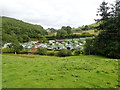
Clywedog Riverside Holiday Home Park
Beside the river Clywedog, serried rows of mobile homes.
Image: © Eirian Evans
Taken: 24 Aug 2020
0.19 miles
3
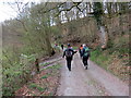
Tuag at Lanidloes / Towards Llanidloes
Cerddwyr yn dilyn heol ddiwyneb tuag at Lanidloes.
Walkers following an unsurfaced road towards Llanidloes (trans. church of Idloes).
Image: © Alan Richards
Taken: 24 Apr 2016
0.24 miles