IMAGES TAKEN NEAR TO
Penstrowed, CAERSWS, SY17 5SG
Introduction
This page details the photographs taken nearby to SY17 5SG by members of the Geograph project.
The Geograph project started in 2005 with the aim of publishing, organising and preserving representative images for every square kilometre of Great Britain, Ireland and the Isle of Man.

There are currently over 7.5m images from over14,400 individuals and you can help contribute to the project by visiting https://www.geograph.org.uk
Image Map
Images are licensed for reuse under creativecommons.org/licenses/by-sa/2.0
Notes
- Clicking on the map will re-center to the selected point.
- The higher the marker number, the further away the image location is from the centre of the postcode.
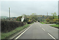
Image Listing (7 Images Found)
Images are licensed for reuse under creativecommons.org/licenses/by-sa/2.0
Image
Details
Distance
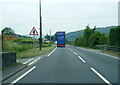
2
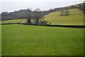
A489 just south of Brynhyfryd
Heading towards Newtown
Image: © John Firth
Taken: 31 Oct 2011
0.08 miles
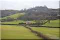
5
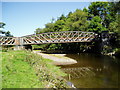
River Severn, Penstrowed railway bridge
The Cambrian Railway Line between Newtown & Machynlleth crosses the River Severn
Considered to be the twenty sixth bridge from the source.
Image: © kevin skidmore
Taken: 8 Sep 2004
0.23 miles
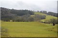
7
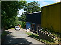
Small industrial units, Penstrowed
One of a complex of about half a dozen industrial units, off the A489 east of Penstrowed.
Image: © Eirian Evans
Taken: 1 Jul 2009
0.24 miles