IMAGES TAKEN NEAR TO
Llawr-y-Glyn, CAERSWS, SY17 5RP
Introduction
This page details the photographs taken nearby to SY17 5RP by members of the Geograph project.
The Geograph project started in 2005 with the aim of publishing, organising and preserving representative images for every square kilometre of Great Britain, Ireland and the Isle of Man.

There are currently over 7.5m images from over14,400 individuals and you can help contribute to the project by visiting https://www.geograph.org.uk
Image Map
Images are licensed for reuse under creativecommons.org/licenses/by-sa/2.0
Notes
- Clicking on the map will re-center to the selected point.
- The higher the marker number, the further away the image location is from the centre of the postcode.
Image Listing (3 Images Found)
Images are licensed for reuse under creativecommons.org/licenses/by-sa/2.0
Image
Details
Distance
1
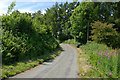
Minor road climbing away from the Nant Cwmcidyn
Seen here about halfway up its climb up the ridge.
Image: © Nigel Brown
Taken: 3 Jul 2010
0.05 miles
2
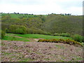
View near Cefn-y-cloddau
Bracken, gorse and oak woodland just beginning to leaf-up.
Image: © Jonathan Billinger
Taken: 5 May 2009
0.13 miles
3
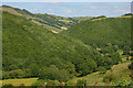
Coed Pen-y-Banc
One of two areas of superb oak woodland, the other being Coed Gwernafon across the valley.
Image: © Nigel Brown
Taken: 3 Jul 2010
0.21 miles