IMAGES TAKEN NEAR TO
Llawr-y-Glyn, CAERSWS, SY17 5RH
Introduction
This page details the photographs taken nearby to SY17 5RH by members of the Geograph project.
The Geograph project started in 2005 with the aim of publishing, organising and preserving representative images for every square kilometre of Great Britain, Ireland and the Isle of Man.

There are currently over 7.5m images from over14,400 individuals and you can help contribute to the project by visiting https://www.geograph.org.uk
Image Map
Images are licensed for reuse under creativecommons.org/licenses/by-sa/2.0
Notes
- Clicking on the map will re-center to the selected point.
- The higher the marker number, the further away the image location is from the centre of the postcode.
Image Listing (9 Images Found)
Images are licensed for reuse under creativecommons.org/licenses/by-sa/2.0
Image
Details
Distance
2
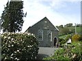
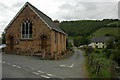
Chapel in Llawr-y-glyn
Chapel on the west edge of Llawr-y-glyn, the building dates from 1871.
Image: © Philip Halling
Taken: 6 Jun 2010
0.11 miles
3
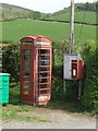
Telephone and Post Boxes
A draughty example in the hills beside the Afon Trannon.
Image: © John M
Taken: 23 Apr 2011
0.13 miles

5
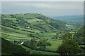
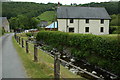
Llawr-y-glyn
Llawr-y-glyn and the Trannon valley viewed from the west.
Image: © Philip Halling
Taken: 6 Jun 2010
0.16 miles
7
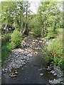
Stream through Llawr-y-glyn
I believe the name of this stream flowing through Llawr-y-glyn is Nant Cwmgwernog, here it is pictured just before its confluence with Afon Trannon.
Image: © Philip Halling
Taken: 6 Jun 2010
0.21 miles
9
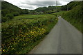
Lane near Llawr-y-glyn
View along a country lane to the west of Llawr-y-glyn towards Gwerafon which can be seen in the background.
Image: © Philip Halling
Taken: 6 Jun 2010
0.24 miles