IMAGES TAKEN NEAR TO
Pontdolgoch, CAERSWS, SY17 5NJ
Introduction
This page details the photographs taken nearby to SY17 5NJ by members of the Geograph project.
The Geograph project started in 2005 with the aim of publishing, organising and preserving representative images for every square kilometre of Great Britain, Ireland and the Isle of Man.

There are currently over 7.5m images from over14,400 individuals and you can help contribute to the project by visiting https://www.geograph.org.uk
Image Map
Images are licensed for reuse under creativecommons.org/licenses/by-sa/2.0
Notes
- Clicking on the map will re-center to the selected point.
- The higher the marker number, the further away the image location is from the centre of the postcode.
Image Listing (7 Images Found)
Images are licensed for reuse under creativecommons.org/licenses/by-sa/2.0
Image
Details
Distance
2
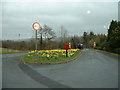
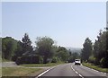
Daffodils and lorries at Pontdolgoch
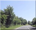
The lorries are on the A470, a very busy road. It was quite poor light so the camera flash triggered, causing the speed limit sign to 'glow'.
Image: © David Medcalf
Taken: 15 Mar 2007
0.11 miles