IMAGES TAKEN NEAR TO
Carno, CAERSWS, SY17 5JU
Introduction
This page details the photographs taken nearby to SY17 5JU by members of the Geograph project.
The Geograph project started in 2005 with the aim of publishing, organising and preserving representative images for every square kilometre of Great Britain, Ireland and the Isle of Man.

There are currently over 7.5m images from over14,400 individuals and you can help contribute to the project by visiting https://www.geograph.org.uk
Image Map
Images are licensed for reuse under creativecommons.org/licenses/by-sa/2.0
Notes
- Clicking on the map will re-center to the selected point.
- The higher the marker number, the further away the image location is from the centre of the postcode.
Image Listing (6 Images Found)
Images are licensed for reuse under creativecommons.org/licenses/by-sa/2.0
Image
Details
Distance
1
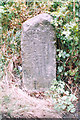
Old Milestone by the A470, Glanhanog-isaf, Carno Parish
By the A470, in parish of Carno (Powys District), Glanhanog-isaf, on verge, on North East side of road.
Inscription reads:-
NEWT
13
MACH
15
Grade II listed by Cadw Reference Number: 17579
https://cadwpublic-api.azurewebsites.net/reports/listedbuilding/FullReport?lang=&id=17579
(Cadw listing information is incorrect for this stone.)
Surveyed
Milestone Society National ID: MOT_NTMC13
Image: © Milestone Society
Taken: Unknown
0.03 miles
2

Milestone - Newtown 15
NE side of the road.
Image: © Adrian Dust
Taken: 12 May 2018
0.04 miles
3
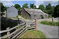
Glanhanog-isaf
Farm buildings at Glanhanog-isaf beside the A470 near Carno.
Image: © Philip Halling
Taken: 3 Jun 2018
0.07 miles
4
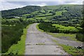
A farmland access road
A farmland access track in the Carno valley opposite Glanhanog.
Image: © Philip Halling
Taken: 3 Jun 2018
0.10 miles
5
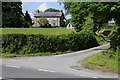
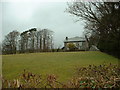
House at Glanhanog-uchaf
House at Glanhanog-uchaf beside the A470.
Image: © Philip Halling
Taken: 3 Jun 2018
0.14 miles