IMAGES TAKEN NEAR TO
Treceiriog, Ty Gwyn Road, CAERSWS, SY17 5HD
Introduction
This page details the photographs taken nearby to Treceiriog, Ty Gwyn Road, SY17 5HD by members of the Geograph project.
The Geograph project started in 2005 with the aim of publishing, organising and preserving representative images for every square kilometre of Great Britain, Ireland and the Isle of Man.

There are currently over 7.5m images from over14,400 individuals and you can help contribute to the project by visiting https://www.geograph.org.uk
Image Map
Images are licensed for reuse under creativecommons.org/licenses/by-sa/2.0
Notes
- Clicking on the map will re-center to the selected point.
- The higher the marker number, the further away the image location is from the centre of the postcode.
Image Listing (62 Images Found)
Images are licensed for reuse under creativecommons.org/licenses/by-sa/2.0
Image
Details
Distance
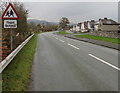
1
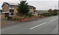
Houses at the northern edge of Caersws
Alongside the B4569 Ty Gwyn Road. The 30mph speed limit increases to the National Speed Limit on the right. http://www.geograph.org.uk/photo/4729323
Image: © Jaggery
Taken: 4 Nov 2015
0.00 miles
2
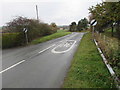
End of the 30 zone at the northern edge of Caersws
The speed limit on the B4569 Ty Gwyn Road increases from 30mph to the National Speed Limit.
Image: © Jaggery
Taken: 4 Nov 2015
0.02 miles
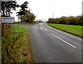
3
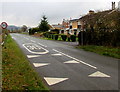
Start of the 30 zone at the northern edge of Caersws
The National Speed Limit on the B4569 Ty Gwyn Road drops to 30mph.
Plas Maldwyn http://www.geograph.org.uk/photo/4729223 is in the background on the right.
Image: © Jaggery
Taken: 4 Nov 2015
0.02 miles
4
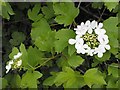
Guelder Rose in the hedge
On the northern edge of Caersws.
Image: © Penny Mayes
Taken: 4 Jun 2012
0.03 miles
5
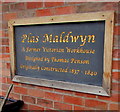
Plas Maldwyn plaque, Caersws
Recording that the large converted building http://www.geograph.org.uk/photo/4729223 in the north of the village
was originally a Victorian workhouse, designed by Thomas Penson, built 1837-1840.
Image: © Jaggery
Taken: 4 Nov 2015
0.04 miles
6
Northern boundary of Caersws
The B4569 Ty Gwyn Road reaches Caersws (Caersŵs in Welsh), a village in Powys,
8km (5 miles) west of Newtown, and about halfway between Shrewsbury and Aberystwyth.
Image: © Jaggery
Taken: 4 Nov 2015
0.04 miles
7
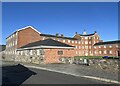
Plas Maldwyn
A former workhouse (built 1837-40), now an apartment block.
Image: © John H Darch
Taken: 9 Feb 2023
0.05 miles
8
Ysgol/School warning sign facing Ty Gwyn Road, Caersws
The bilingual (Welsh/English) sign is on the approach to Caersws Community Primary School (out of shot).
Image: © Jaggery
Taken: 4 Nov 2015
0.06 miles
9
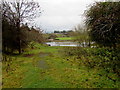
Track towards the River Severn, Caersws
From the B4569 Ty Gwyn Road.
Image: © Jaggery
Taken: 4 Nov 2015
0.06 miles
10
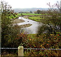
Bend in the River Severn, Caersws
Viewed from Ty Gwyn Road.
Image: © Jaggery
Taken: 4 Nov 2015
0.06 miles