IMAGES TAKEN NEAR TO
Oakley Park, LLANDINAM, SY17 5BE
Introduction
This page details the photographs taken nearby to SY17 5BE by members of the Geograph project.
The Geograph project started in 2005 with the aim of publishing, organising and preserving representative images for every square kilometre of Great Britain, Ireland and the Isle of Man.

There are currently over 7.5m images from over14,400 individuals and you can help contribute to the project by visiting https://www.geograph.org.uk
Image Map
Images are licensed for reuse under creativecommons.org/licenses/by-sa/2.0
Notes
- Clicking on the map will re-center to the selected point.
- The higher the marker number, the further away the image location is from the centre of the postcode.
Image Listing (4 Images Found)
Images are licensed for reuse under creativecommons.org/licenses/by-sa/2.0
Image
Details
Distance
2
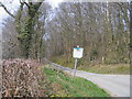
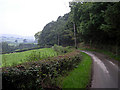
Lon Coediog ger Oakley Park / Wooded lane near Oakley Park
Lon Coediog ger Oakley Park / Wooded lane with old battered "No Through Road Sign" near Oakley Park.
Image: © Ian Medcalf
Taken: 2 Apr 2007
0.12 miles
3
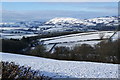
Snowy hillside near Rhydfaes
Looking in the direction of Bryn y Fan.
Image: © Bill Boaden
Taken: 15 Jan 2013
0.23 miles
4
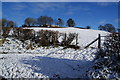
Pen-y-banc
A farm with a splendid hilltop setting.
Image: © Bill Boaden
Taken: 15 Jan 2013
0.23 miles