IMAGES TAKEN NEAR TO
LLANDINAM, SY17 5BB
Introduction
This page details the photographs taken nearby to SY17 5BB by members of the Geograph project.
The Geograph project started in 2005 with the aim of publishing, organising and preserving representative images for every square kilometre of Great Britain, Ireland and the Isle of Man.

There are currently over 7.5m images from over14,400 individuals and you can help contribute to the project by visiting https://www.geograph.org.uk
Image Map
Images are licensed for reuse under creativecommons.org/licenses/by-sa/2.0
Notes
- Clicking on the map will re-center to the selected point.
- The higher the marker number, the further away the image location is from the centre of the postcode.
Image Listing (6 Images Found)
Images are licensed for reuse under creativecommons.org/licenses/by-sa/2.0
Image
Details
Distance
1
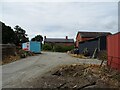
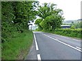
A470 passed Upper Penrhuddlan
Entrance to Upper Penrhuddlan to the right
Image: © John Firth
Taken: 31 Oct 2011
0.13 miles
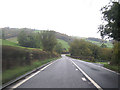
4
A470 at Upper Penrhuddlan, looking northeast
The A470 in this direction goes to Y Drenewydd (Newtown), via the A489. The farm buildings at Upper Penrhuddlan can be glimpsed on both sides of the road in the distance.
Image: © P L Chadwick
Taken: 25 May 2009
0.22 miles
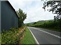
5
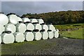
Upper Penrhuddlan
Alongside the A470 were these silage bags glinting in the sunshine. Beyond, sheep pasture rises gently towards Coed y Gaer.
Image: © Graham Horn
Taken: 25 Oct 2009
0.22 miles