IMAGES TAKEN NEAR TO
LLANDINAM, SY17 5AZ
Introduction
This page details the photographs taken nearby to SY17 5AZ by members of the Geograph project.
The Geograph project started in 2005 with the aim of publishing, organising and preserving representative images for every square kilometre of Great Britain, Ireland and the Isle of Man.

There are currently over 7.5m images from over14,400 individuals and you can help contribute to the project by visiting https://www.geograph.org.uk
Image Map
Images are licensed for reuse under creativecommons.org/licenses/by-sa/2.0
Notes
- Clicking on the map will re-center to the selected point.
- The higher the marker number, the further away the image location is from the centre of the postcode.
Image Listing (2 Images Found)
Images are licensed for reuse under creativecommons.org/licenses/by-sa/2.0
Image
Details
Distance
1
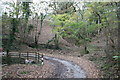
Wooded valley near Pencraig
This picture is taken in a tiny valley in an area of natural native woodland. The tiny stream responsible for the valley is culverted at this hairpin bend on a lane that usually sees no more than an occasional tractor. The road itself is slowly disappearing under the fallen autumn leaves.
Image: © John Gibson
Taken: 9 Nov 2007
0.08 miles
2
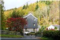
Dol-ffin
A house buried deep in Nant Feinion, a side valley of the Severn valley.
Image: © Graham Horn
Taken: 25 Oct 2009
0.22 miles