IMAGES TAKEN NEAR TO
LLANDINAM, SY17 5AS
Introduction
This page details the photographs taken nearby to SY17 5AS by members of the Geograph project.
The Geograph project started in 2005 with the aim of publishing, organising and preserving representative images for every square kilometre of Great Britain, Ireland and the Isle of Man.

There are currently over 7.5m images from over14,400 individuals and you can help contribute to the project by visiting https://www.geograph.org.uk
Image Map
Images are licensed for reuse under creativecommons.org/licenses/by-sa/2.0
Notes
- Clicking on the map will re-center to the selected point.
- The higher the marker number, the further away the image location is from the centre of the postcode.
Image Listing (9 Images Found)
Images are licensed for reuse under creativecommons.org/licenses/by-sa/2.0
Image
Details
Distance
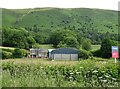
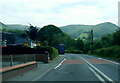
4
Across the Severn valley
From a layby on the looking west across the valley towards Coed Mawr (Big Wood) in Image
Image: © Graham Horn
Taken: 25 Oct 2009
0.08 miles
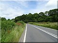
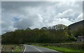
7
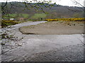
River Severn
Here the river Severn is wide and shallow, meandering in a wide river valley, just south of Llandinam.
Image: © Eirian Evans
Taken: 24 Apr 2006
0.23 miles
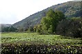
9
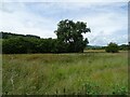
![Llandinam Gravels Nature Reserve [3]](https://s0.geograph.org.uk/geophotos/05/02/25/5022504_c56d2591_120x120.jpg)
Llandinam Gravels Nature Reserve [3]
Looking east across the valley of the River Severn, from the southern entrance. The site is run by Montgomeryshire Wildlife Trust, and is one of the 10 most important in the UK for its riverside shingle habitat. The River Severn is along the distant line of trees.
Image: © Christine Johnstone
Taken: 18 Jun 2016
0.25 miles