1
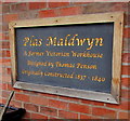
Plas Maldwyn
A former workhouse (built 1837-40), now an apartment block.
Image: © John H Darch
Taken: 9 Feb 2023
0.05 miles
2
Plas Maldwyn plaque, Caersws
Recording that the large converted building http://www.geograph.org.uk/photo/4729223 in the north of the village
was originally a Victorian workhouse, designed by Thomas Penson, built 1837-1840.
Image: © Jaggery
Taken: 4 Nov 2015
0.06 miles
3
Houses at the northern edge of Caersws
Alongside the B4569 Ty Gwyn Road. The 30mph speed limit increases to the National Speed Limit on the right. http://www.geograph.org.uk/photo/4729323
Image: © Jaggery
Taken: 4 Nov 2015
0.06 miles
4
West side of Plas Maldwyn, Caersws
Luxury apartments viewed from Ty Gwyn Road. Occupying a rectangular site about 90 metres by 80 metres,
the building was named Plas Maldwyn on conversion and modernisation in 2006. Plas is not Welsh for place.
It means a grand building, such as a palace, mansion or hall. A plaque http://www.geograph.org.uk/photo/4729211 records that this building was originally a Victorian workhouse, designed by Thomas Penson, built 1837-1840.
Image: © Jaggery
Taken: 4 Nov 2015
0.06 miles
5
Plas Maldwyn, Caersws
Luxury apartments in the north of the village.
The current appearance of the building dates from conversion to apartments in 2006.
The plaque http://www.geograph.org.uk/photo/4729211 on the right records that the building is a former early Victorian workhouse.
Image: © Jaggery
Taken: 4 Nov 2015
0.06 miles
6
New development in Caersws
Apparently this site was the old workhouse and later a hospital until re-development recently into a large-ish apartment block. Where you once went if you were really poor or couldn't look after yourself you now have to pay a premium to live. Ain't it always the way comrade?
Image: © Jeremy Bolwell
Taken: 25 Aug 2010
0.07 miles
7
Start of the 30 zone at the northern edge of Caersws
The National Speed Limit on the B4569 Ty Gwyn Road drops to 30mph.
Plas Maldwyn http://www.geograph.org.uk/photo/4729223 is in the background on the right.
Image: © Jaggery
Taken: 4 Nov 2015
0.07 miles
8
End of the 30 zone at the northern edge of Caersws
The speed limit on the B4569 Ty Gwyn Road increases from 30mph to the National Speed Limit.
Image: © Jaggery
Taken: 4 Nov 2015
0.07 miles
9
Plas Maldwyn side road, Caersws
From Ty Gwyn Road past the edge of Plas Maldwyn apartments. http://www.geograph.org.uk/photo/4729248
Image: © Jaggery
Taken: 4 Nov 2015
0.08 miles
10
Plas Maldwyn, Caersws
The workhouse for the Newtown and Llanidloes area was built at Caersws in the 1840's. After the Second World War, the workhouse building was used to accommodate handicapped patients under the name of Llys Maldwyn, until its closure in 1999. It has now been converted into luxury apartments and maisonettes and renamed Plas Maldwyn.
Image: © Eirian Evans
Taken: 1 Jul 2009
0.08 miles


