IMAGES TAKEN NEAR TO
Kerry, NEWTOWN, SY16 4NZ
Introduction
This page details the photographs taken nearby to SY16 4NZ by members of the Geograph project.
The Geograph project started in 2005 with the aim of publishing, organising and preserving representative images for every square kilometre of Great Britain, Ireland and the Isle of Man.

There are currently over 7.5m images from over14,400 individuals and you can help contribute to the project by visiting https://www.geograph.org.uk
Image Map
Images are licensed for reuse under creativecommons.org/licenses/by-sa/2.0
Notes
- Clicking on the map will re-center to the selected point.
- The higher the marker number, the further away the image location is from the centre of the postcode.
Image Listing (6 Images Found)
Images are licensed for reuse under creativecommons.org/licenses/by-sa/2.0
Image
Details
Distance
1
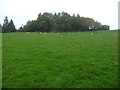
The old motte above Kerry
Now wooded this was once the site of a Norman motte, overlooking Kerry and the surrounding landscape.
Image: © Jeremy Bolwell
Taken: 9 Oct 2010
0.08 miles
2
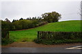
Rolling green field near Kerry
There is a motte and bailey castle up there somewhere, but you cannot see it from this road.
Image: © Bill Boaden
Taken: 30 Oct 2014
0.13 miles
3

Building in progress
A new property being built in Common Road, Kerry.
Image: © John H Darch
Taken: 1 Aug 2021
0.16 miles
4
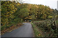
Autumn leaves and lane junction near Kerry
A bale is being transported by the tractor ahead.
Image: © Bill Boaden
Taken: 30 Oct 2014
0.16 miles
5
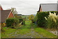
Field access between the houses
This is already an outlying part of Kerry.
Image: © Bill Boaden
Taken: 30 Oct 2014
0.19 miles
6
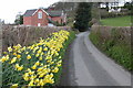
Daffodils by Pen-aran Cottage
As a result of the late spring the daffodils are still in flower on 1st May on the lane by Pen-aran Cottage.
Image: © Philip Halling
Taken: 1 May 2006
0.25 miles