IMAGES TAKEN NEAR TO
Kerry, NEWTOWN, SY16 4LW
Introduction
This page details the photographs taken nearby to SY16 4LW by members of the Geograph project.
The Geograph project started in 2005 with the aim of publishing, organising and preserving representative images for every square kilometre of Great Britain, Ireland and the Isle of Man.

There are currently over 7.5m images from over14,400 individuals and you can help contribute to the project by visiting https://www.geograph.org.uk
Image Map
Images are licensed for reuse under creativecommons.org/licenses/by-sa/2.0
Notes
- Clicking on the map will re-center to the selected point.
- The higher the marker number, the further away the image location is from the centre of the postcode.
Image Listing (9 Images Found)
Images are licensed for reuse under creativecommons.org/licenses/by-sa/2.0
Image
Details
Distance
1
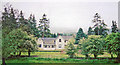
Former Kerry station, 2001
View southward: terminus of ex-Cambrian Railways branch from Abermule, closed to passengers 9/2/31, to goods 1/5/56; now a desirable residence.
Image: © Ben Brooksbank
Taken: 27 May 2001
0.06 miles
2
The Old Smithy by Kerry Station at Glanmule
Echoing the style of the station building at the Kerry terminus of the short-lived branch line from Abermule, presumably the smithy was associated with the railway. The line, which rose about 100m up the dingle from Abermule, was closed to passengers in 1931 but continued to carry timber until 1956.
See also Image
Image: © Penny Mayes
Taken: 5 Sep 2013
0.12 miles
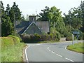
3
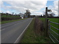
A489 and B4368 road junction at Glanmule
Looking eastwards towards Sarn
Image: © John Firth
Taken: 8 Feb 2011
0.17 miles
4
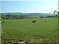
Farmland in the valley of The Mule
The Mule river is just beyond this field. Mule being the anglicised version of 'Miwl'.
Image: © David Medcalf
Taken: 2 May 2007
0.18 miles
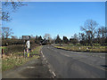
5
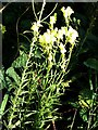
Common toadflax beside the A489 at Glanmule
Competing with nettles and brambles on the verge.
Image: © Penny Mayes
Taken: 5 Sep 2013
0.20 miles
6
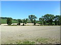
View north from the A489 at Glanmule
I'm not sure what the crop was here, possibly wheat. Arable cultivation is rare in this area where farming is usually all about livestock.
Image: © Penny Mayes
Taken: 5 Sep 2013
0.21 miles
8
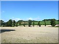
View NNW from the A489 at Glanmule
I'm not sure what the crop was here, possibly wheat. Arable cultivation is rare in this area where farming is usually all about livestock.
The nearer line of trees mark the course of Afon Miwl.
Image: © Penny Mayes
Taken: 5 Sep 2013
0.23 miles
9
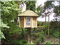
The Ultimate tree-house, with suspension bridge access
Every child should have one (And why can't every grown-up, too?)
Image: © mike morley
Taken: 28 Jun 2009
0.24 miles