IMAGES TAKEN NEAR TO
Mochdre, NEWTOWN, SY16 4JW
Introduction
This page details the photographs taken nearby to SY16 4JW by members of the Geograph project.
The Geograph project started in 2005 with the aim of publishing, organising and preserving representative images for every square kilometre of Great Britain, Ireland and the Isle of Man.

There are currently over 7.5m images from over14,400 individuals and you can help contribute to the project by visiting https://www.geograph.org.uk
Image Map
Images are licensed for reuse under creativecommons.org/licenses/by-sa/2.0
Notes
- Clicking on the map will re-center to the selected point.
- The higher the marker number, the further away the image location is from the centre of the postcode.
Image Listing (1 Images Found)
Images are licensed for reuse under creativecommons.org/licenses/by-sa/2.0
Image
Details
Distance
1
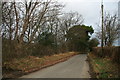
Lane beside Cae'n Coed Dingle
This quiet country lane running towards Mochdre lies on the eastern side of the mixed woodland that forms Cae'n Coed Dingle and at this point stands at about 250m.
Image: © John Gibson
Taken: 25 Jan 2008
0.09 miles