IMAGES TAKEN NEAR TO
Sarn, NEWTOWN, SY16 4HJ
Introduction
This page details the photographs taken nearby to SY16 4HJ by members of the Geograph project.
The Geograph project started in 2005 with the aim of publishing, organising and preserving representative images for every square kilometre of Great Britain, Ireland and the Isle of Man.

There are currently over 7.5m images from over14,400 individuals and you can help contribute to the project by visiting https://www.geograph.org.uk
Image Map
Images are licensed for reuse under creativecommons.org/licenses/by-sa/2.0
Notes
- Clicking on the map will re-center to the selected point.
- The higher the marker number, the further away the image location is from the centre of the postcode.
Image Listing (10 Images Found)
Images are licensed for reuse under creativecommons.org/licenses/by-sa/2.0
Image
Details
Distance
1
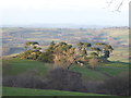
Earthwork near City, Powys
A fine site.
Image: © Jeremy Bolwell
Taken: 26 Dec 2016
0.15 miles
2
Part of the hill fort above City
Yes - the trees really are leaning outwards at that angle. That's perhaps why some of them have been removed, unless it was to prevent the fort becoming completely overgrown.
Image: © Richard Law
Taken: 30 Nov 2008
0.18 miles
3
Tree at the field boundary
With roosting Starlings. As we passed we disturbed many roosting Starlings who skimmed off to hopefully return once we passed by.
Image: © Jeremy Bolwell
Taken: 26 Dec 2016
0.19 miles
4
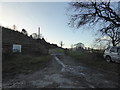
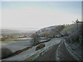
Hillside track
With a Coleg Powys sign.
Image: © Jeremy Bolwell
Taken: 26 Dec 2016
0.19 miles
5
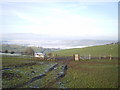
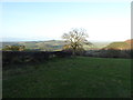
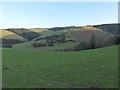
Pastures above Cefn-y-bryn
Cefn-y-bryn is the small farm just out of sight beyond the field on the right. There is a junction of bridleways at this gate, from which one bridleway leads down to Cefn-y-bryn, and the other heads off westwards towards Lower Hill in Image
Image: © Richard Law
Taken: 30 Nov 2008
0.19 miles
6
View to the earthwork
What an impressive site. Must investigate more closely next time.
Image: © Jeremy Bolwell
Taken: 26 Dec 2016
0.19 miles
7
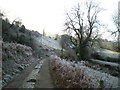
Footpath becomes bridleway
At the gate/cattlegrid just ahead of here, the bridleway coming up from Old Hall continues up hill to the smallholding of Cefn-y-bryn.
Image: © Richard Law
Taken: 30 Nov 2008
0.20 miles
8
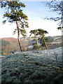
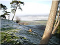
Scots Pines on the embankment of the fort
There's not much to be seen of the fort apart from some earth banks and ditches, and they're not the most impressive in this part of the world. The fort obviously hada stand of many more pines once upon a time, but now several of them have been felled to clear the view slightly.
Image: © Richard Law
Taken: 30 Nov 2008
0.20 miles
9
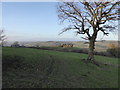
The north side of the hill
The Scots pines on the right are growing on the old fort in Image, and the hill in the far distance is Corndon, which lies (mainly) in Image
Image: © Richard Law
Taken: 30 Nov 2008
0.21 miles
10
View to Round Bank
Impressive hillside slope.
Image: © Jeremy Bolwell
Taken: 26 Dec 2016
0.24 miles