IMAGES TAKEN NEAR TO
Kerry, NEWTOWN, SY16 4DX
Introduction
This page details the photographs taken nearby to SY16 4DX by members of the Geograph project.
The Geograph project started in 2005 with the aim of publishing, organising and preserving representative images for every square kilometre of Great Britain, Ireland and the Isle of Man.

There are currently over 7.5m images from over14,400 individuals and you can help contribute to the project by visiting https://www.geograph.org.uk
Image Map
Images are licensed for reuse under creativecommons.org/licenses/by-sa/2.0
Notes
- Clicking on the map will re-center to the selected point.
- The higher the marker number, the further away the image location is from the centre of the postcode.
Image Listing (2 Images Found)
Images are licensed for reuse under creativecommons.org/licenses/by-sa/2.0
Image
Details
Distance
1
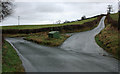
Up The Junction
Country Lane Junction with branch leading upwards towards Little Cefn-caled and Cefn Hyfryd, while the straight lane continues towards Llanmerewig.
Image: © J Scott
Taken: 5 Jan 2008
0.22 miles
2
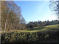
Small pasture beside the wood at Glascoed
Viewed from the lane to Llanmerewig on a sunny Christmas morning.
Image: © Penny Mayes
Taken: 25 Dec 2019
0.25 miles