IMAGES TAKEN NEAR TO
Dolfor, NEWTOWN, SY16 4BL
Introduction
This page details the photographs taken nearby to SY16 4BL by members of the Geograph project.
The Geograph project started in 2005 with the aim of publishing, organising and preserving representative images for every square kilometre of Great Britain, Ireland and the Isle of Man.

There are currently over 7.5m images from over14,400 individuals and you can help contribute to the project by visiting https://www.geograph.org.uk
Image Map
Images are licensed for reuse under creativecommons.org/licenses/by-sa/2.0
Notes
- Clicking on the map will re-center to the selected point.
- The higher the marker number, the further away the image location is from the centre of the postcode.
Image Listing (4 Images Found)
Images are licensed for reuse under creativecommons.org/licenses/by-sa/2.0
Image
Details
Distance
1
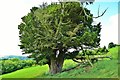
One Of A Pair
Two fine old Veteran Common Yews sit looking South from Garreg Hill. Much exposed to the elements they have had to fight for their existence.
Image: © paul wood
Taken: 17 Jul 2016
0.11 miles
2
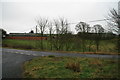
Farm buildings, Garreg
This long range of farm buildings stands at Garreg on the southern side of the A483, about a mile north-west of Dolfor.
Image: © John Gibson
Taken: 1 Jan 2008
0.21 miles
4
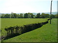
Pasture land west of the A483
Rich pastures abound in the country to the south-west of Newtown.
Image: © Jonathan Billinger
Taken: 14 May 2008
0.23 miles