IMAGES TAKEN NEAR TO
Dolfor, NEWTOWN, SY16 4AZ
Introduction
This page details the photographs taken nearby to SY16 4AZ by members of the Geograph project.
The Geograph project started in 2005 with the aim of publishing, organising and preserving representative images for every square kilometre of Great Britain, Ireland and the Isle of Man.

There are currently over 7.5m images from over14,400 individuals and you can help contribute to the project by visiting https://www.geograph.org.uk
Image Map
Images are licensed for reuse under creativecommons.org/licenses/by-sa/2.0
Notes
- Clicking on the map will re-center to the selected point.
- The higher the marker number, the further away the image location is from the centre of the postcode.
Image Listing (7 Images Found)
Images are licensed for reuse under creativecommons.org/licenses/by-sa/2.0
Image
Details
Distance
1
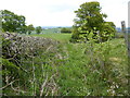
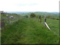
Overgrown footpath
Lovely to struggle through...but undoubtedly a nature highway.
Image: © Jeremy Bolwell
Taken: 6 May 2019
0.07 miles
2
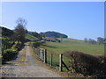
Lon Fferm, Crugyn / Crugyn Farm Track
Dyma lon fferm syn arwain i Grugyn /A track leading to Crugyn Farm
Image: © Ian Medcalf
Taken: 2 Apr 2007
0.07 miles
3
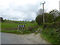
Track through fields
Its becomes a footpath slightly higher up.
Image: © Jeremy Bolwell
Taken: 6 May 2019
0.12 miles
4
Old pathway on the hillside
Now fenced.
Image: © Jeremy Bolwell
Taken: 6 May 2019
0.14 miles
5
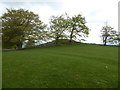
Burial mound near the Cross Dyke at the western end of the Kerry Ridgeway
Packed with monuments around here.
If this was Wiltshire or Southern England everyone would have heard of these.
Image: © Jeremy Bolwell
Taken: 6 May 2019
0.20 miles
6
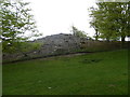
Burial mound near the Cross Dyke at the western end of the Kerry Ridgeway
Impressive site.
Image: © Jeremy Bolwell
Taken: 6 May 2019
0.21 miles