IMAGES TAKEN NEAR TO
Dolfor, NEWTOWN, SY16 4AT
Introduction
This page details the photographs taken nearby to SY16 4AT by members of the Geograph project.
The Geograph project started in 2005 with the aim of publishing, organising and preserving representative images for every square kilometre of Great Britain, Ireland and the Isle of Man.

There are currently over 7.5m images from over14,400 individuals and you can help contribute to the project by visiting https://www.geograph.org.uk
Image Map
Images are licensed for reuse under creativecommons.org/licenses/by-sa/2.0
Notes
- Clicking on the map will re-center to the selected point.
- The higher the marker number, the further away the image location is from the centre of the postcode.
Image Listing (6 Images Found)
Images are licensed for reuse under creativecommons.org/licenses/by-sa/2.0
Image
Details
Distance
1
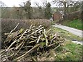
Wood stack and Upper Wig
A roadside scene by the farm of Upper Wig, anglicised as Weeg.
Image: © Jonathan Wilkins
Taken: 17 Mar 2014
0.02 miles
2
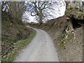
Steep lane
A very steep, incised lane leading between Lower and Upper Wig. The Welsh habit of prolonging certain vowels leads to the interesting anglicising of the names to Weeg at times. The tree on the right looks very precarious, forming a wooden wall at the roadside.
Image: © Jonathan Wilkins
Taken: 17 Mar 2014
0.03 miles
3
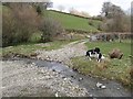
Track and ford
A convenient watering stop where the footpath crosses one of the tributaries of the Afon Miwl.
Image: © Jonathan Wilkins
Taken: 17 Mar 2014
0.08 miles
4
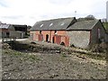
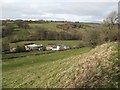
Farm buildings
Working buildings at Lower Wig, seen across the Afon Miwl. The narrow road to Upper Wig crosses the bridge at the left of the image.
Image: © Jonathan Wilkins
Taken: 17 Mar 2014
0.16 miles
5
Lower Wig
The farm of Lower Wig sits at the head of the Miwl valley on level ground formed by the meandering river. It is a beautiful, secluded place. The farmhouse has seen recent renovation and looks particularly fine.
Image: © Jonathan Wilkins
Taken: 17 Mar 2014
0.18 miles
6
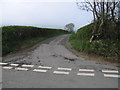
Dead end road
The no through lane to Ty-cornel off the no through road to Wig.
Image: © Neville Goodman
Taken: 8 May 2008
0.20 miles