IMAGES TAKEN NEAR TO
Dolfor, NEWTOWN, SY16 4AF
Introduction
This page details the photographs taken nearby to SY16 4AF by members of the Geograph project.
The Geograph project started in 2005 with the aim of publishing, organising and preserving representative images for every square kilometre of Great Britain, Ireland and the Isle of Man.

There are currently over 7.5m images from over14,400 individuals and you can help contribute to the project by visiting https://www.geograph.org.uk
Image Map
Images are licensed for reuse under creativecommons.org/licenses/by-sa/2.0
Notes
- Clicking on the map will re-center to the selected point.
- The higher the marker number, the further away the image location is from the centre of the postcode.
Image Listing (3 Images Found)
Images are licensed for reuse under creativecommons.org/licenses/by-sa/2.0
Image
Details
Distance
1
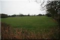
Sheep pasture by Cwm Graig
Viewed across recently trimmed field hedges uphill towards Hollybank, this sheep pasture lies at around 188m.
Image: © John Gibson
Taken: 1 Jan 2008
0.13 miles
2
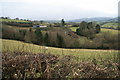
Sheep pasture at Cwm Graig
Sheltered sheep pastures and farm at Cwm Graig, just below the A483 near Glascoed.
Image: © John Gibson
Taken: 1 Jan 2008
0.18 miles