IMAGES TAKEN NEAR TO
Dolfor, NEWTOWN, SY16 4AD
Introduction
This page details the photographs taken nearby to SY16 4AD by members of the Geograph project.
The Geograph project started in 2005 with the aim of publishing, organising and preserving representative images for every square kilometre of Great Britain, Ireland and the Isle of Man.

There are currently over 7.5m images from over14,400 individuals and you can help contribute to the project by visiting https://www.geograph.org.uk
Image Map
Images are licensed for reuse under creativecommons.org/licenses/by-sa/2.0
Notes
- Clicking on the map will re-center to the selected point.
- The higher the marker number, the further away the image location is from the centre of the postcode.
Image Listing (3 Images Found)
Images are licensed for reuse under creativecommons.org/licenses/by-sa/2.0
Image
Details
Distance
1
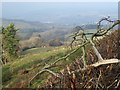
View from Upper Dolfor Road, New Year 2020
Looking back towards the western end of Newtown and beyond, shrouded by mist.
Image: © Penny Mayes
Taken: 1 Jan 2020
0.10 miles
3
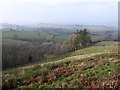
View from Upper Dolfor Road, New Year 2020
The sun crept through the cloud as I drove up the hill but visibility was generally poor.
Taken at 12:14.
Image: © Penny Mayes
Taken: 1 Jan 2020
0.21 miles