IMAGES TAKEN NEAR TO
Tregynon, NEWTOWN, SY16 3PY
Introduction
This page details the photographs taken nearby to SY16 3PY by members of the Geograph project.
The Geograph project started in 2005 with the aim of publishing, organising and preserving representative images for every square kilometre of Great Britain, Ireland and the Isle of Man.

There are currently over 7.5m images from over14,400 individuals and you can help contribute to the project by visiting https://www.geograph.org.uk
Image Map
Images are licensed for reuse under creativecommons.org/licenses/by-sa/2.0
Notes
- Clicking on the map will re-center to the selected point.
- The higher the marker number, the further away the image location is from the centre of the postcode.
Image Listing (6 Images Found)
Images are licensed for reuse under creativecommons.org/licenses/by-sa/2.0
Image
Details
Distance
1
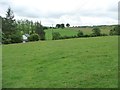
Power lines crossing farmland north of The Dairy
On the west side of the road to Adfa.
Image: © Christine Johnstone
Taken: 18 Jun 2016
0.03 miles
2
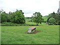
Sheep pasture with empty feeder, near The Dairy
Plenty of grass available.
Image: © Christine Johnstone
Taken: 18 Jun 2016
0.04 miles
3
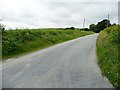
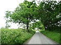
The road from Bwlch y fridd to Adfa
Heading north-west from a 287 metre spot height.
Image: © Christine Johnstone
Taken: 18 Jun 2016
0.05 miles
4
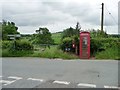
Communication hot spot at 283 metres above sea level
A T junction, two footpaths, a post box and a phone box, but not even a hamlet.
Image: © Christine Johnstone
Taken: 18 Jun 2016
0.05 miles
5
The road to Tregynon
Just east of its junction with the Bwlch y ffridd - Adfa road.
Image: © Christine Johnstone
Taken: 18 Jun 2016
0.08 miles
6
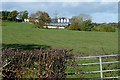
Towards Bryn Coch
The fields are remarkably empty, but this seems to be a mixed sheep and cattle farm.
Image: © Graham Horn
Taken: 25 Oct 2009
0.19 miles