IMAGES TAKEN NEAR TO
Bryn Lane, NEWTOWN, SY16 3LZ
Introduction
This page details the photographs taken nearby to Bryn Lane, SY16 3LZ by members of the Geograph project.
The Geograph project started in 2005 with the aim of publishing, organising and preserving representative images for every square kilometre of Great Britain, Ireland and the Isle of Man.

There are currently over 7.5m images from over14,400 individuals and you can help contribute to the project by visiting https://www.geograph.org.uk
Image Map
Images are licensed for reuse under creativecommons.org/licenses/by-sa/2.0
Notes
- Clicking on the map will re-center to the selected point.
- The higher the marker number, the further away the image location is from the centre of the postcode.
Image Listing (3 Images Found)
Images are licensed for reuse under creativecommons.org/licenses/by-sa/2.0
Image
Details
Distance
1
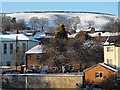
Signs of tobogganing on the Bryn
Heavy snowfalls brought a (for some) welcome extension to the school holidays and local children have been enjoying the slopes above the town.
In the foreground, left to right, the Roman Catholic church, Severn Terrace and Bodafon.
Image: © Penny Mayes
Taken: 7 Jan 2010
0.10 miles
2
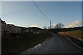
Bryn Lane, Newtown
Leading out of town. Newtown Hospital is at its lower end. To the left is a building site where four or five new "executive homes" are being built.
Image: © John Winder
Taken: 30 Jan 2015
0.21 miles
3
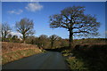
Bryn Lane
A view of Bryn Lane near Hendidley, early on a sunny March morning, which belies the very cold weather and the snow and hail of an hour earlier. The lane is flanked by neatly trimmed traditional hedges which, like the trees, have yet to develop any new season greenery.
Image: © John Gibson
Taken: 21 Mar 2008
0.23 miles