IMAGES TAKEN NEAR TO
Aberhafesp, NEWTOWN, SY16 3LU
Introduction
This page details the photographs taken nearby to SY16 3LU by members of the Geograph project.
The Geograph project started in 2005 with the aim of publishing, organising and preserving representative images for every square kilometre of Great Britain, Ireland and the Isle of Man.

There are currently over 7.5m images from over14,400 individuals and you can help contribute to the project by visiting https://www.geograph.org.uk
Image Map
Images are licensed for reuse under creativecommons.org/licenses/by-sa/2.0
Notes
- Clicking on the map will re-center to the selected point.
- The higher the marker number, the further away the image location is from the centre of the postcode.
Image Listing (2 Images Found)
Images are licensed for reuse under creativecommons.org/licenses/by-sa/2.0
Image
Details
Distance
1
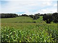
Maize crop near Rhyd-y-felin
Taken two months after http://www.geograph.org.uk/photo/3100859 and the stripes of the sowing lines are still visible.
Eleven Acre Coppice on the left.
Image: © Penny Mayes
Taken: 26 Aug 2012
0.18 miles
2
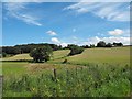
Three fields of young maize near Rhyd-y-felin
The brook in the foreground meanders down the hill in the centre of the photo, its course marked by the trees.
The nearest field, just across the brook is rather boggy in this corner and puddles are visible in http://www.geograph.org.uk/photo/3100908.
Eleven Acre Coppice is seen on the left.
Image: © Penny Mayes
Taken: 25 Jun 2012
0.24 miles