IMAGES TAKEN NEAR TO
Aberhafesp, NEWTOWN, SY16 3LP
Introduction
This page details the photographs taken nearby to SY16 3LP by members of the Geograph project.
The Geograph project started in 2005 with the aim of publishing, organising and preserving representative images for every square kilometre of Great Britain, Ireland and the Isle of Man.

There are currently over 7.5m images from over14,400 individuals and you can help contribute to the project by visiting https://www.geograph.org.uk
Image Map
Images are licensed for reuse under creativecommons.org/licenses/by-sa/2.0
Notes
- Clicking on the map will re-center to the selected point.
- The higher the marker number, the further away the image location is from the centre of the postcode.
Image Listing (4 Images Found)
Images are licensed for reuse under creativecommons.org/licenses/by-sa/2.0
Image
Details
Distance
1
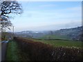
Looking east from Garth
The frost remains everywhere the sun has not touched it.
Image: © Penny Mayes
Taken: 30 Nov 2008
0.16 miles
2
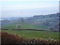
Pasture near Garth
I think a dog being walked along the road had spooked the sheep which moved off in a vee formation.
Image: © Penny Mayes
Taken: 30 Nov 2008
0.16 miles
3
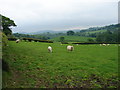
Fields Near Garth Hill
Looking towards the middle of the grid square.
Image: © Ian Paterson
Taken: 27 May 2008
0.16 miles
4
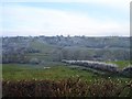
Pasture near Garth
Highgate Brook runs along the valley at the bottom of this field.
Image: © Penny Mayes
Taken: 30 Nov 2008
0.17 miles