IMAGES TAKEN NEAR TO
Aberhafesp, NEWTOWN, SY16 3HP
Introduction
This page details the photographs taken nearby to SY16 3HP by members of the Geograph project.
The Geograph project started in 2005 with the aim of publishing, organising and preserving representative images for every square kilometre of Great Britain, Ireland and the Isle of Man.

There are currently over 7.5m images from over14,400 individuals and you can help contribute to the project by visiting https://www.geograph.org.uk
Image Map
Images are licensed for reuse under creativecommons.org/licenses/by-sa/2.0
Notes
- Clicking on the map will re-center to the selected point.
- The higher the marker number, the further away the image location is from the centre of the postcode.
Image Listing (5 Images Found)
Images are licensed for reuse under creativecommons.org/licenses/by-sa/2.0
Image
Details
Distance
1
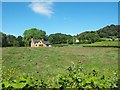
New timber-framed house near Rhyd-lydan
I was surprised to see this completely new house being built.
There is no sign of it in Philip Halling's pic from 2007 http://www.geograph.org.uk/photo/540379.
Image: © Penny Mayes
Taken: 12 Jun 2010
0.10 miles
2
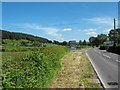
The turning to Bwlch-y-ffridd
From the B4568 between Llanwnog and Aberhafesp. Sheriff's Wood on the left is in Image
Image: © Penny Mayes
Taken: 12 Jun 2010
0.11 miles
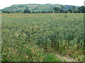
5
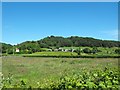
Wern-ddu
Sheriff's Wood is the backdrop. The house on the left is called Brynteg
Image: © Penny Mayes
Taken: 12 Jun 2010
0.24 miles