IMAGES TAKEN NEAR TO
Penymaes, NEWTOWN, SY16 3BQ
Introduction
This page details the photographs taken nearby to Penymaes, SY16 3BQ by members of the Geograph project.
The Geograph project started in 2005 with the aim of publishing, organising and preserving representative images for every square kilometre of Great Britain, Ireland and the Isle of Man.

There are currently over 7.5m images from over14,400 individuals and you can help contribute to the project by visiting https://www.geograph.org.uk
Image Map
Images are licensed for reuse under creativecommons.org/licenses/by-sa/2.0
Notes
- Clicking on the map will re-center to the selected point.
- The higher the marker number, the further away the image location is from the centre of the postcode.
Image Listing (5 Images Found)
Images are licensed for reuse under creativecommons.org/licenses/by-sa/2.0
Image
Details
Distance
1
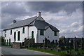
Adfa Calvinist Methodist Chapel
with large graveyard
Image: © Peter Standing
Taken: 7 May 2006
0.06 miles
2
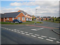
Treganol, Adfa
An estate of "executive homes" uneasily grafted onto a traditional village.
Image: © Oliver Dixon
Taken: 16 Sep 2007
0.11 miles
3
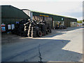
Garage and agricultural engineers, Adfa
Signs that this is a working village.
Image: © Oliver Dixon
Taken: 16 Sep 2007
0.21 miles
5
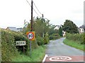
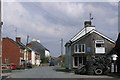
Adfa village
Entering the village from the west.
Image: © James Allan
Taken: 2 Sep 2007
0.24 miles