IMAGES TAKEN NEAR TO
Aberbechan, NEWTOWN, SY16 3AU
Introduction
This page details the photographs taken nearby to SY16 3AU by members of the Geograph project.
The Geograph project started in 2005 with the aim of publishing, organising and preserving representative images for every square kilometre of Great Britain, Ireland and the Isle of Man.

There are currently over 7.5m images from over14,400 individuals and you can help contribute to the project by visiting https://www.geograph.org.uk
Image Map
Images are licensed for reuse under creativecommons.org/licenses/by-sa/2.0
Notes
- Clicking on the map will re-center to the selected point.
- The higher the marker number, the further away the image location is from the centre of the postcode.
Image Listing (5 Images Found)
Images are licensed for reuse under creativecommons.org/licenses/by-sa/2.0
Image
Details
Distance
1
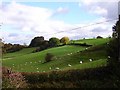
East from the B4568
Rolling pasture near Garn Wood.
Image: © Penny Mayes
Taken: 17 Oct 2007
0.14 miles
2
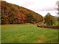
Autumn colour, Garn Wood
Beside the road from Llanllwchaiarn to Aberbecham.
Image: © Penny Mayes
Taken: 17 Oct 2007
0.16 miles
3
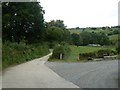
Road to Pant Farm
Leading off the B4389.
Image: © James Allan
Taken: 2 Sep 2007
0.18 miles
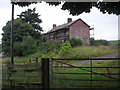
5
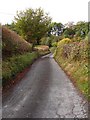
Lower Gwestydd Lane
This leads to Lower Gwestydd farm as a public road. It continues on to Upper Gwestydd as a track.
Image: © Penny Mayes
Taken: 17 Oct 2007
0.25 miles