IMAGES TAKEN NEAR TO
NEWTOWN, SY16 3AA
Introduction
This page details the photographs taken nearby to SY16 3AA by members of the Geograph project.
The Geograph project started in 2005 with the aim of publishing, organising and preserving representative images for every square kilometre of Great Britain, Ireland and the Isle of Man.

There are currently over 7.5m images from over14,400 individuals and you can help contribute to the project by visiting https://www.geograph.org.uk
Image Map
Images are licensed for reuse under creativecommons.org/licenses/by-sa/2.0
Notes
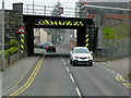
- Clicking on the map will re-center to the selected point.
- The higher the marker number, the further away the image location is from the centre of the postcode.
Image Listing (85 Images Found)
Images are licensed for reuse under creativecommons.org/licenses/by-sa/2.0
Image
Details
Distance
1
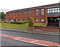
Hope Day Nursery, Newtown
Viewed across the A483 Dolfor Road. Located at the northern end of Hope Church, http://www.geograph.org.uk/photo/3584098
Hope Day Nursery provides care for children from c3 months to 5 years old.
Image: © Jaggery
Taken: 4 Aug 2013
0.05 miles
2
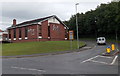
Hope Church, Newtown
Situated on the corner of the A483 Dolfor Road and Heol Treowen, Hope Church is a contemporary, Bible-based community church with a Pentecostal heritage.
Newtown Pentecostal Church began at a crusade meeting in a tent in 1948. In the early 1950s the church became affiliated to the Assemblies of God. Meetings were held in various venues in the town until in 1977, a new church was built here. There have been various extensions and upgrades since then.
Image: © Jaggery
Taken: 4 Aug 2013
0.06 miles
3
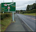
Warning sign for two overhead bridges, Newtown
The sign is alongside the A483 Dolfor Road. One http://www.geograph.org.uk/photo/3584168 of the bridges is in the background.
Image: © Jaggery
Taken: 4 Aug 2013
0.08 miles
5
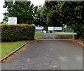
Visitors on school business only, Newtown High School
One notice on the gates at the Dolfor Road entrance to Newtown High School shows Visitors on school business only. The other notice shows No right of way through school grounds.
Image: © Jaggery
Taken: 4 Aug 2013
0.08 miles
6
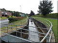
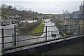
Water channel alongside Dolfor Road, Newtown
Much of this channel is underground, flowing through conduits. Here, alongside Dolfor Road, it is at the surface for about 70 metres.
Image: © Jaggery
Taken: 4 Aug 2013
0.09 miles
7
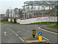
Newtown, Dolfor Road
New building under construction at the corner of Heol Treowen and Delfor Road. A sign on the hoarding states the Hope Church (Image]) has relocated.
Image: © David Dixon
Taken: 15 Apr 2016
0.09 miles
8
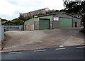
Howells fuel oils Dolfor Road depot, Newtown
Viewed across the A483 Dolfor Road from near this http://www.geograph.org.uk/photo/3584168 railway bridge.
Image: © Jaggery
Taken: 4 Aug 2013
0.09 miles
9
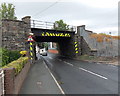
Dolfor Road Railway Bridge Newtown
Railway bridge near Newtown centre.
Image: © David Dixon
Taken: 15 Apr 2016
0.11 miles
10
Dolfor Road railway bridge, Newtown
The bridge carries the Cambrian Line railway over the A483 Dolfor Road about
500 metres WSW of Newtown railway station. Headroom is shown as 4 metres (13' 3").
Image: © Jaggery
Taken: 4 Aug 2013
0.11 miles