IMAGES TAKEN NEAR TO
Canal Road, NEWTOWN, SY16 2JN
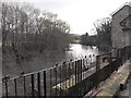
Introduction
This page details the photographs taken nearby to Canal Road, SY16 2JN by members of the Geograph project.
The Geograph project started in 2005 with the aim of publishing, organising and preserving representative images for every square kilometre of Great Britain, Ireland and the Isle of Man.

There are currently over 7.5m images from over14,400 individuals and you can help contribute to the project by visiting https://www.geograph.org.uk
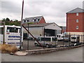
Image Map
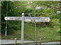
Images are licensed for reuse under creativecommons.org/licenses/by-sa/2.0
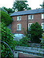
Notes
- Clicking on the map will re-center to the selected point.
- The higher the marker number, the further away the image location is from the centre of the postcode.
Image Listing (125 Images Found)
Images are licensed for reuse under creativecommons.org/licenses/by-sa/2.0
Image
Details
Distance
1
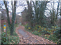
Cycle route through the woods (no horses)
This is National Cycle Route 81 through the Severn valley just downstream of Newtown / Y Drenewydd. The signpost at left shows that, unusually for a cycle route, horseriding is not permitted.
Image: © Stephen Craven
Taken: 20 Nov 2008
0.01 miles
2
Canal Road
Canal Road, as seen from the riverside walk
Image: © Henry Spooner
Taken: 6 Mar 2011
0.02 miles
3
Canal Road
View from Lonesome Lane Newtown
Image: © Henry Spooner
Taken: 14 Feb 2011
0.02 miles
4
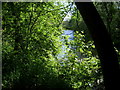
A view of the river looking East , Newtown, Powys
A view through the trees, of the river Severn taken from the across Wales Cycle Track at Llanllwchaiarn, Newtown, Powys.
Image: © Henry Spooner
Taken: 26 May 2009
0.03 miles
5
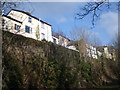
28 Llanllwchaiarn Road, Newtown
One half of a pair of more-or-less identical early or mid 19th century weavers' houses, which attracted a Grade II listing https://britishlistedbuildings.co.uk/300008124-28-llanllwchaiarn-road-powys-newtown-and-llanllwchaiarn#.YxOFvHbMLIU in 1988
Image: © Richard Law
Taken: 9 Jul 2022
0.03 miles
6
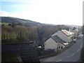
Bus Garage, Dolafon Road, Newtown, Powys
A local bus garage on Dolafon Road, Newtown, Powys.
Image: © Henry Spooner
Taken: 8 Jun 2009
0.04 miles
7
Sign on the Canal Road at Llanllwchaiarn
A dual language sign on the Across Wales route.
Image: © Henry Spooner
Taken: 5 May 2009
0.04 miles
8
River Severn passes the Pump House
The Pump House (now a private residence) stands between the course of the Montgomery Canal (filled in at this point) and the river. Presumably it served to maintain water levels in the canal, which terminated a short distance west of here.
Image: © Penny Mayes
Taken: 25 Dec 2008
0.05 miles
9
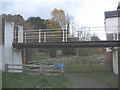
Bridge to the old pump house
A close-up of the bridge seen in Image Presumably this originally crossed the canal.
Image: © Stephen Craven
Taken: 20 Nov 2008
0.05 miles
10
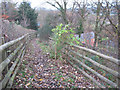
Public footpath from Hillside Avenue to Canal Road
The Explorer map shows the public footpath running along the recently developed road called Hillside Avenue and then down this path to Canal Road (B4568).
Image: © Stephen Craven
Taken: 20 Nov 2008
0.05 miles