IMAGES TAKEN NEAR TO
Fron Lane, NEWTOWN, SY16 2EL
Introduction
This page details the photographs taken nearby to Fron Lane, SY16 2EL by members of the Geograph project.
The Geograph project started in 2005 with the aim of publishing, organising and preserving representative images for every square kilometre of Great Britain, Ireland and the Isle of Man.

There are currently over 7.5m images from over14,400 individuals and you can help contribute to the project by visiting https://www.geograph.org.uk
Image Map
Images are licensed for reuse under creativecommons.org/licenses/by-sa/2.0
Notes
- Clicking on the map will re-center to the selected point.
- The higher the marker number, the further away the image location is from the centre of the postcode.
Image Listing (182 Images Found)
Images are licensed for reuse under creativecommons.org/licenses/by-sa/2.0
Image
Details
Distance
1
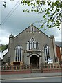
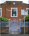
Former chapel, now children's nursery, Newtown
With a plaque: Welsh Congregational/Memorial Chapel/Erected/1865/Site given by the Hon. Lord Sudeley
Image: © David Smith
Taken: 5 May 2023
0.10 miles
2
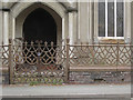
Cast iron railings and gates to chapel building, Milford Road, Newtown, Powys
While the railings seem to be of cast iron elements, the gates appear to have a frame of wrought iron strips that hold the cast iron panels.
Image: © Robin Stott
Taken: 17 Jun 2014
0.12 miles
3
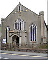
Chapel building, Milford Road, Newtown, Powys
The plaque above the central window reads: Welsh Congregational / Memorial Chapel / Erected / 1865. / Site given by the Hon. Lord Sudeley. A sign at the door says: Little World Day Nursery, although the gates appear to be chained and padlocked shut. Weeds are taking hold in the entrance. Google Streetview shows a sign on the left, apparently from 2009, headed Y Capel Coffa and giving the times of services in Welsh and English at the Crescent Christian Centre / Canolfan Gristnogol y Cilgant (a church on the corner of Milford Road and Long Bridge Street). For the chapel this looks like closure..
Image: © Robin Stott
Taken: 17 Jun 2014
0.12 miles
4
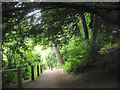
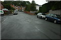
Footpath down to Dolerw Park from Milford Road, Newtown, Powys
Image: © Robin Stott
Taken: 17 Jun 2014
0.12 miles
6
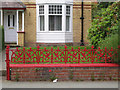
Cast iron low fence to a front garden, Milford Road, Newtown, Powys
Image: © Robin Stott
Taken: 17 Jun 2014
0.13 miles
7
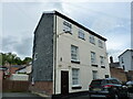
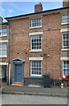
32 Union Street, Newtown
Marked on the maps as 31 & 32, but since the door on the right (no 31) has been blocked, it's fair too assume it's now a single property. It dates from the early 19th century, and was originally built as a pair of cottages with weavers' lofts in the attic. The whole house attracted a Grade II listing https://britishlistedbuildings.co.uk/300008183-no32-union-street-penygloddfa-powys-newtown-and-llanllwchaiarn#.YvAfj3bMLIU in 1988.
Image: © Richard Law
Taken: 13 May 2022
0.14 miles
8
Cast iron gate to Masonic Hall, Milford Road, Newtown, Powys
Image: © Robin Stott
Taken: 17 Jun 2014
0.14 miles
9
19 Crescent Street, Newtown
A typical example of the many listed houses found along the length of Image; it is an early 19th century terraced property, which was Grade II listed https://britishlistedbuildings.co.uk/300008079-19-crescent-street-penygloddfa-powys-newtown-and-llanllwchaiarn#.Ys8tT3bMLIU & https://cadwpublic-api.azurewebsites.net/reports/listedbuilding/FullReport?lang=en&id=8079 in 1988.
Image: © Richard Law
Taken: 13 May 2022
0.14 miles
10
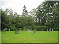
Gorsedd Circle, Dolerw Park, Newtown, Powys
Image: © Robin Stott
Taken: 17 Jun 2014
0.14 miles