IMAGES TAKEN NEAR TO
Bryn Meadows, NEWTOWN, SY16 2DS
Introduction
This page details the photographs taken nearby to Bryn Meadows, SY16 2DS by members of the Geograph project.
The Geograph project started in 2005 with the aim of publishing, organising and preserving representative images for every square kilometre of Great Britain, Ireland and the Isle of Man.

There are currently over 7.5m images from over14,400 individuals and you can help contribute to the project by visiting https://www.geograph.org.uk
Image Map
Images are licensed for reuse under creativecommons.org/licenses/by-sa/2.0
Notes
- Clicking on the map will re-center to the selected point.
- The higher the marker number, the further away the image location is from the centre of the postcode.
Image Listing (101 Images Found)
Images are licensed for reuse under creativecommons.org/licenses/by-sa/2.0
Image
Details
Distance
1
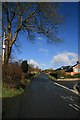
Bryn Lane, Newtown / Y Drenewydd
A view up Bryn Lane as it climbs through the modern residential area of Bryn Bank and Lower Bryn, towards the farms on Bryn Hill and beyond. Taken from the junction with Llanfair Road on the outskirts of Newtown/Y Drenewydd.
Image: © John Gibson
Taken: 21 Mar 2008
0.05 miles
2
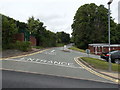
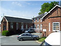
Main entrance to Montgomery County Infirmary, Newtown Hospital
Viewed across Bryn Lane. The hospital has X-ray facilities, physiotherapy, occupational therapy, a dietician and provides a wide range of outpatient clinics.
Image: © Jaggery
Taken: 16 Jun 2013
0.06 miles
3
Outpatients department, Newtown Hospital
Viewed across Bryn Lane. The Wales NHS website shows the full name of the hospital as
Montgomery County Infirmary, Newtown Hospital.
Image: © Jaggery
Taken: 16 Jun 2013
0.08 miles
4
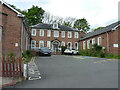
Montgomery County Infirmary buildings
The older part of the Newtown Hospital complex
Image: © Richard Law
Taken: 13 May 2022
0.09 miles
5
Newtown County Infirmary
County Infirmary, Newtown, Powys
Image: © Henry Spooner
Taken: 16 May 2009
0.09 miles
6
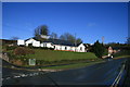
County Infirmary, Newtown, Powys
This mix of very modern and well-maintained older buildings on Llanfair Road, by the bottom of Bryn Lane, comprises the Montgomery County Infirmary at Newtown - Clafdy Sirol Maldwyn Y Drenewydd. Thirty minutes previously, this area had been the centre of blizzard conditions.
Image: © John Gibson
Taken: 21 Mar 2008
0.09 miles
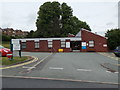
7
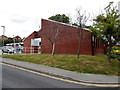
Bryn Heulog Rehabilitation Unit, Newtown
Viewed across Bryn Lane. The unit is part of Montgomery County Infirmary Newtown Hospital.
Image: © Jaggery
Taken: 16 Jun 2013
0.09 miles
8

County Infirmary, Newtown, Powys
The old part of Newtown Infirmary, Newtown, Powys
Image: © Henry Spooner
Taken: 16 May 2009
0.10 miles
9
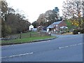
Coed y Nant and the entrance to Coed Mawr
From Llanfair Road.
The sheep have created diagonal terraces on the steep field behind the house.
The brook which runs between Llanfair Road and Sycamore Drive before joining the Severn, crosses under the road on the left.
Image: © Penny Mayes
Taken: 3 Nov 2011
0.10 miles
10
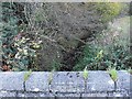
The brook runs under the Llanfair Road
Close to the entrance to Coed y Nant and the entrance to Coed Mawr http://www.geograph.org.uk/photo/2706950.
Image: © Penny Mayes
Taken: 3 Nov 2011
0.10 miles