IMAGES TAKEN NEAR TO
Llanfair Road, NEWTOWN, SY16 2DQ
Introduction
This page details the photographs taken nearby to Llanfair Road, SY16 2DQ by members of the Geograph project.
The Geograph project started in 2005 with the aim of publishing, organising and preserving representative images for every square kilometre of Great Britain, Ireland and the Isle of Man.

There are currently over 7.5m images from over14,400 individuals and you can help contribute to the project by visiting https://www.geograph.org.uk
Image Map
Images are licensed for reuse under creativecommons.org/licenses/by-sa/2.0
Notes
- Clicking on the map will re-center to the selected point.
- The higher the marker number, the further away the image location is from the centre of the postcode.
Image Listing (443 Images Found)
Images are licensed for reuse under creativecommons.org/licenses/by-sa/2.0
Image
Details
Distance
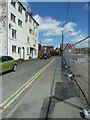
1
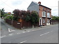
Corner of Fairfield Drive and Llanfair Road, Newtown
Viewed across Llanfair Road.
Image: © Jaggery
Taken: 16 Jun 2013
0.02 miles
2
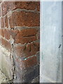
OS benchmark, Newtown - 15 Llanfair Road
An OS cutmark on the wall by the nearest corner of Image, which was levelled in 1976 at 115.799m above Ordnance Datum Newlyn.
Image: © Richard Law
Taken: 13 May 2022
0.03 miles
3
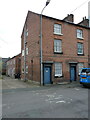
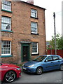
15 & 16 Llanfair Road, Newtown
Nos 15 & 16 are at the left end of a terrace of 5 very similar early 19th century Georgian town houses, all of which were Grade II listed in 1988. The specific listing for no 15 is at https://britishlistedbuildings.co.uk/300008118-15-llanfair-road-powys-newtown-and-llanllwchaiarn#.YupnMXbMI2w but they are all described in the text of that.
Image: © Richard Law
Taken: 13 May 2022
0.03 miles
4
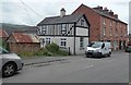
Building variety, Llanfair Road, Newtown
The small building on the left is at the edge of an area of corrugated buildings on the SE side of Llanfair Road. The black and white building is on the corner of Francis Place.
Image: © Jaggery
Taken: 16 Jun 2013
0.04 miles
5
19 Llanfair Road, Newtown
No 19 is the other end of the terrace of 5 very similar houses referred to in Image, all of which date from the early 19th century, and all of which were Grade II listed in 1988. The details of all of them are in a common text, found at https://britishlistedbuildings.co.uk/300008122-19-llanfair-road-powys-newtown-and-llanllwchaiarn#.Yupsy3bMI2w
Image: © Richard Law
Taken: 13 May 2022
0.04 miles
6
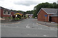
Llys Ifor, Newtown
Residential cul-de-sac viewed from Canal Road.
A Kingdom Hall of Jehovah's Witnesses http://www.geograph.org.uk/photo/1141487 is on the right.
Image: © Jaggery
Taken: 16 Jun 2013
0.04 miles
7

Powys Theatre, Newtown
Housed in the old Llanllwchaiarn School since 1968, the Newtown Amateur Dramatic Society started in 1934.
There are more details of the history of the society on their website.
Image: © Penny Mayes
Taken: 30 Jan 2009
0.05 miles
8
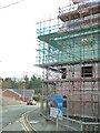
Severnside Yard construction site November 2015
Corner of Frankwell Street and Canal Road with the Kingdom Hall in the background.
Image: © Penny Mayes
Taken: 13 Nov 2015
0.06 miles
9
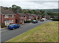
Cwm Llanfair houses, Newtown
Cwm Llanfair is a cul-de-sac on the east side of Llanfair Road.
Image: © Jaggery
Taken: 16 Jun 2013
0.06 miles
10
The view along Frankwell Street
In late April 2015
Image: © Penny Mayes
Taken: 28 Apr 2015
0.06 miles