IMAGES TAKEN NEAR TO
Llanfair Road, NEWTOWN, SY16 2DG
Introduction
This page details the photographs taken nearby to Llanfair Road, SY16 2DG by members of the Geograph project.
The Geograph project started in 2005 with the aim of publishing, organising and preserving representative images for every square kilometre of Great Britain, Ireland and the Isle of Man.

There are currently over 7.5m images from over14,400 individuals and you can help contribute to the project by visiting https://www.geograph.org.uk
Image Map
Images are licensed for reuse under creativecommons.org/licenses/by-sa/2.0
Notes
- Clicking on the map will re-center to the selected point.
- The higher the marker number, the further away the image location is from the centre of the postcode.
Image Listing (478 Images Found)
Images are licensed for reuse under creativecommons.org/licenses/by-sa/2.0
Image
Details
Distance
1
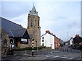
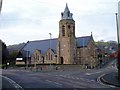
All Saints Church, Newtown
Standing at the junction of Llanfair Road (ahead) with School Lane (left) and Commercial Street. The church was built in 1890 at the expense of Sir Pryce Pryce-Jones as a "chapel-of-ease" for the parish at Llanllwchaiarn. It is an early work by Aston (later Sir Aston) Webb who went on to much greater things, including Admiralty Arch, The Mall, and the East Wing of Buckingham Palace in London. All Saints is of Llanymynech limestone with Grinshill (Shropshire) freestone dressings and has an unusual octagonal tower.
The grid line runs diagonally through the church building.
Image: © Penny Mayes
Taken: 30 Jan 2009
0.02 miles
2
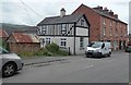
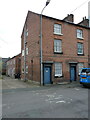
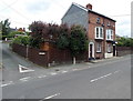
Building variety, Llanfair Road, Newtown
The small building on the left is at the edge of an area of corrugated buildings on the SE side of Llanfair Road. The black and white building is on the corner of Francis Place.
Image: © Jaggery
Taken: 16 Jun 2013
0.02 miles
3
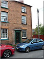
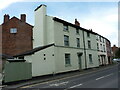
19 Llanfair Road, Newtown
No 19 is the other end of the terrace of 5 very similar houses referred to in Image, all of which date from the early 19th century, and all of which were Grade II listed in 1988. The details of all of them are in a common text, found at https://britishlistedbuildings.co.uk/300008122-19-llanfair-road-powys-newtown-and-llanllwchaiarn#.Yupsy3bMI2w
Image: © Richard Law
Taken: 13 May 2022
0.02 miles
4
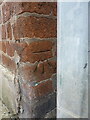
OS benchmark, Newtown - 15 Llanfair Road
An OS cutmark on the wall by the nearest corner of Image, which was levelled in 1976 at 115.799m above Ordnance Datum Newlyn.
Image: © Richard Law
Taken: 13 May 2022
0.02 miles
5
15 & 16 Llanfair Road, Newtown
Nos 15 & 16 are at the left end of a terrace of 5 very similar early 19th century Georgian town houses, all of which were Grade II listed in 1988. The specific listing for no 15 is at https://britishlistedbuildings.co.uk/300008118-15-llanfair-road-powys-newtown-and-llanllwchaiarn#.YupnMXbMI2w but they are all described in the text of that.
Image: © Richard Law
Taken: 13 May 2022
0.02 miles
6
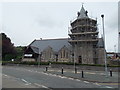
Tower scaffolding, All Saints Church, Newtown
This June 2013 view across the B4568 Commercial Street shows scaffolding encasing the church tower. Here's http://www.geograph.org.uk/photo/1141371 a view of the church without scaffolding.
Image: © Jaggery
Taken: 16 Jun 2013
0.03 miles
7
25 Commercial Street, Newtown
Built around the early 19th century, and Grade II listed https://britishlistedbuildings.co.uk/300008047-25-commercial-street-penygloddfa-powys-newtown-and-llanllwchaiarn#.YsdGk3bMLIU in May 1988.
Image: © Richard Law
Taken: 13 May 2022
0.03 miles
8
All Saints Church, Newtown
Standing at the junction of Llanfair Road (right) with School Lane (ahead right) and Commercial Street. The church was built in 1890 at the expense of Sir Pryce Pryce-Jones as a "chapel-of-ease" for the parish at Llanllwchaiarn. It is an early work by Aston (later Sir Aston) Webb who went on to much greater things, including Admiralty Arch, The Mall, and the East Wing of Buckingham Palace in London. All Saints is of Llanymynech limestone with Grinshill (Shropshire) freestone dressings and has an unusual octagonal tower.
The grid line runs diagonally through the church building, just to the left of the tower.
Image: © Penny Mayes
Taken: 30 Jan 2009
0.03 miles
9
Corner of Fairfield Drive and Llanfair Road, Newtown
Viewed across Llanfair Road.
Image: © Jaggery
Taken: 16 Jun 2013
0.03 miles
10
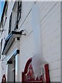
Overflow ice floe
This overflow at the Bell Hotel on Commercial Street has built up a drape of ice over the sign below in the recent extended freezing weather.
Image: © Penny Mayes
Taken: 25 Dec 2010
0.03 miles