IMAGES TAKEN NEAR TO
Canal Road, NEWTOWN, SY16 2AS
Introduction
This page details the photographs taken nearby to Canal Road, SY16 2AS by members of the Geograph project.
The Geograph project started in 2005 with the aim of publishing, organising and preserving representative images for every square kilometre of Great Britain, Ireland and the Isle of Man.

There are currently over 7.5m images from over14,400 individuals and you can help contribute to the project by visiting https://www.geograph.org.uk
Image Map
Images are licensed for reuse under creativecommons.org/licenses/by-sa/2.0
Notes
- Clicking on the map will re-center to the selected point.
- The higher the marker number, the further away the image location is from the centre of the postcode.
Image Listing (765 Images Found)
Images are licensed for reuse under creativecommons.org/licenses/by-sa/2.0
Image
Details
Distance
1
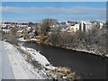
Snowy view across the Severn
This view looks almost directly north along the grid line from the western end of the Halfpenny footbridge. The house with its gable end facing the river is in SO1191.
Image: © Penny Mayes
Taken: 27 Nov 2010
0.03 miles
2
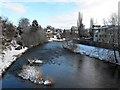
Snowy view down the Severn from the Long Bridge
Compare with Philip Halling's summer view http://www.geograph.org.uk/photo/1973820.
Image: © Penny Mayes
Taken: 27 Nov 2010
0.03 miles
3
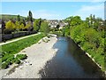
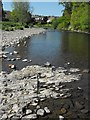
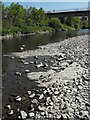
Low water in the Severn
After the driest April for years river levels dropped lower than I have seen them before. We had finally had some rain a day or so before I took this photo so it must have been even lower than this.
Compare with September 2008 http://www.geograph.org.uk/photo/992895 and October 2008 http://www.geograph.org.uk/photo/993346.
Image: © Penny Mayes
Taken: 27 Apr 2011
0.04 miles
4
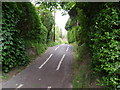
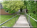
Golwgydre Lane
The path connecting Canal Road to Edwards Field.
Image: © Henry Spooner
Taken: 9 May 2009
0.04 miles
5
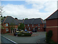
Edwards Field, Newtown, Powys
Flats on Edwards Field,Newtown, Powys
Image: © Henry Spooner
Taken: 17 May 2009
0.05 miles
6
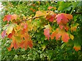
Autumn colour
The change in colour on this maple seemed to be working its way inwards from the extremities. The variegated variety in the background had not yet started to turn.
Image: © Penny Mayes
Taken: 7 Oct 2008
0.05 miles
7
Exposed bedrock in the River Severn
The bedrock hereabouts is sedimentary mudstone.
This view shows that the layers emerge at an angle so, rather than presenting a flat pavement there are rows of ridges. See also http://www.geograph.org.uk/photo/2509655.
Image: © Penny Mayes
Taken: 27 Apr 2011
0.05 miles
8
The rear access to Mill Close Meeting Hall
The rear access from Wire Walk to Mill Close Meeting Hall
Image: © Henry Spooner
Taken: 9 May 2009
0.05 miles
9
Exposed bedrock in the River Severn
The bedrock hereabouts is sedimentary mudstone.
See also http://www.geograph.org.uk/photo/2509661.
Image: © Penny Mayes
Taken: 27 Apr 2011
0.05 miles
10
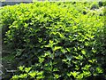
Plants by the Severn
I'm not sure what the bulk of these are. There are nettles in the shadowy foreground but the lighter coloured, more deeply lobed leaves are something else.
This part of the river bank is regularly under water when water levels are higher.
Image: © Penny Mayes
Taken: 27 Apr 2011
0.05 miles