IMAGES TAKEN NEAR TO
Llys Hafren, Old Kerry Road, NEWTOWN, SY16 1LR
Introduction
This page details the photographs taken nearby to Llys Hafren, Old Kerry Road, SY16 1LR by members of the Geograph project.
The Geograph project started in 2005 with the aim of publishing, organising and preserving representative images for every square kilometre of Great Britain, Ireland and the Isle of Man.

There are currently over 7.5m images from over14,400 individuals and you can help contribute to the project by visiting https://www.geograph.org.uk
Image Map
Images are licensed for reuse under creativecommons.org/licenses/by-sa/2.0
Notes
- Clicking on the map will re-center to the selected point.
- The higher the marker number, the further away the image location is from the centre of the postcode.
Image Listing (580 Images Found)
Images are licensed for reuse under creativecommons.org/licenses/by-sa/2.0
Image
Details
Distance
1
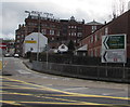
Direction signs pointing towards Old Kerry Road, Newtown
3 (miles) from Kerry and 12 from Churchstoke.
Image: © Jaggery
Taken: 1 Feb 2017
0.02 miles
2
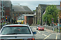
Traffic lights on Pool Road, Newtown
This is at the junction with Old Kerry Road.
Image: © Bill Boaden
Taken: 19 May 2011
0.02 miles
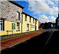
3
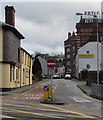
Old Kerry Road, Newtown
A No Entry (except buses) sign is at the northwest end of Old Kerry Road.
Image: © Jaggery
Taken: 1 Feb 2017
0.02 miles
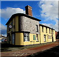
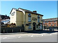
4
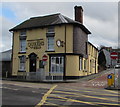
Queens Head pub, Newtown
On the corner of Pool Road and Old Kerry Road. There is no apostrophe in Queens. http://www.geograph.org.uk/photo/5269569 to the name sign.
The Late Georgian (early 19th century) building was Grade II listed in 1988.
Image: © Jaggery
Taken: 1 Feb 2017
0.03 miles
5
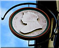
Queens Head name sign, Newtown
In a bracket on the wall here. http://www.geograph.org.uk/photo/5269558
Image: © Jaggery
Taken: 1 Feb 2017
0.03 miles
6
Old Kerry Road side of the Queens Head pub, Newtown
The Late Georgian (early 19th century) building was Grade II listed in 1988.
http://www.geograph.org.uk/photo/5269558 to the Pool Road side of the pub.
Image: © Jaggery
Taken: 1 Feb 2017
0.03 miles
7
The Queen's Head public house, Newtown
Situated on the corner of Pool Road and Kerry Road, The Queen's Head is an early 19th century (Georgian) building which was Grade II listed https://britishlistedbuildings.co.uk/300008164-queens-head-ph-newtown-and-llanllwchaiarn#.YxtzF3bMLIU in 1988.
Image: © Richard Law
Taken: 10 Jul 2022
0.03 miles
8
Old Kerry Road bus lane, Newtown
A No Entry (except buses) sign http://www.geograph.org.uk/photo/5269593 is behind the camera.
Image: © Jaggery
Taken: 1 Feb 2017
0.03 miles
9
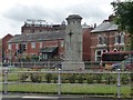
War memorial, Newtown, Powys
Between New Road and Shortbridge Street.
Image: © Christine Johnstone
Taken: 29 Jun 2015
0.03 miles
10
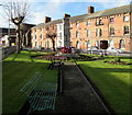
Benches near the War Memorial, Newtown (Powys)
In a grass triangle between New Road and Shortbridge Street.
Image: © Jaggery
Taken: 1 Feb 2017
0.03 miles