1
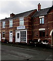
Oakfield Terrace, Newtown
Viewed across Llanidloes Road in February 2017. A former post office is now Kate's Hair Studio. http://www.geograph.org.uk/photo/5269747
Image: © Jaggery
Taken: 1 Feb 2017
0.01 miles
2
Kate's Hair Studio, Oakfield Terrace, Newtown
Located in a converted former post office, set back from the south side of Llanidloes Road.
Image: © Jaggery
Taken: 1 Feb 2017
0.01 miles
3
BT phonebox on a Newtown corner
On the corner of Llanidloes Road and Oakfield Terrace.
Image: © Jaggery
Taken: 1 Feb 2017
0.02 miles
4
BT phonebox on a Newtown corner
On the corner of Oakfield Terrace and Llanidloes Road, viewed on February 1st 2017.
The poster on the box is outdated. It advertises Peter Jolly's Circus which was in town last September.
Image: © Jaggery
Taken: 1 Feb 2017
0.02 miles
5
Newtown Evangelical Church, Newtown, Powys
The Evangelical Church, Vaynor, Newtown, Powys
Image: © Henry Spooner
Taken: 27 May 2009
0.03 miles
6
Footpath to a low railway bridge, Newtown
From the south side of Llanidloes Road towards a bridge carrying
the Cambrian Line railway, located 1.5km west of Newtown railway station.
Image: © Jaggery
Taken: 1 Feb 2017
0.03 miles
7
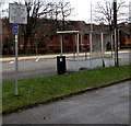
Damaged bus shelter, Llanidloes Road, Newtown
Viewed on February 1st 2017. The bilingual (Welsh/English) Powys County Council notice states that the leaving of vehicles for sale on the highway is prohibited under the terms of the Highways Act 1980. Offenders will be prosecuted. Maximum fine £1,000. The small blue sign indicates National Cycle Network Route 81.
Image: © Jaggery
Taken: 1 Feb 2017
0.04 miles
8
Heol Vaynor gas installation, Newtown
The Wales & West Utilities gas installation is alongside Heol Vaynor near the corner of Llanidloes Road.
Image: © Jaggery
Taken: 1 Feb 2017
0.04 miles
9
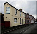
Oakfield Terrace, Newtown
Row of houses extending for 80 metres, set back from the south side of Llanidloes Road.
Image: © Jaggery
Taken: 1 Feb 2017
0.04 miles
10
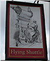
Flying Shuttle pub name sign, Newtown
Facing Heol Vaynor at the entrance path to this http://www.geograph.org.uk/photo/5269756 suburban pub. Depicted is a flying shuttle, patented by
John Kay in 1733. The flying shuttle was a major development in the industrialisation of weaving during the early years of the Industrial Revolution. It enabled a single weaver to weave much wider fabrics. It could also be mechanised to create automatic machine looms.
Image: © Jaggery
Taken: 1 Feb 2017
0.04 miles


