IMAGES TAKEN NEAR TO
Old Kerry Road, NEWTOWN, SY16 1BS
Introduction
This page details the photographs taken nearby to Old Kerry Road, SY16 1BS by members of the Geograph project.
The Geograph project started in 2005 with the aim of publishing, organising and preserving representative images for every square kilometre of Great Britain, Ireland and the Isle of Man.

There are currently over 7.5m images from over14,400 individuals and you can help contribute to the project by visiting https://www.geograph.org.uk
Image Map
Images are licensed for reuse under creativecommons.org/licenses/by-sa/2.0
Notes
- Clicking on the map will re-center to the selected point.
- The higher the marker number, the further away the image location is from the centre of the postcode.
Image Listing (404 Images Found)
Images are licensed for reuse under creativecommons.org/licenses/by-sa/2.0
Image
Details
Distance
1

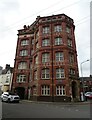
Agriculture House, Newtown
Viewed across Old Kerry Road. Built in 1895 as a factory for Pryce-Jones near the Pryce-Jones Royal Welsh Warehouse. http://www.geograph.org.uk/photo/2810148 The building has had several later uses, such as an Admiralty victualling station during the Second World War and as offices for the Agricultural Executive Committee.
Image: © Jaggery
Taken: 23 Jun 2013
0.00 miles
2
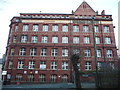
Agriculture House, Newtown
Grade II listed five storey and attic red brick building. Built 1895 as a factory for Pryce Jones on the site of an earlier one. Served as Admiralty victualling station during World War II. Taken over by the Agricultural Executive Committee and later ADAS.
Image: © JThomas
Taken: 4 Jul 2024
0.01 miles
3
A Pryce-Jones building in Newtown
The date of this edifice is 1895 and it marks the high water mark maybe of the Pryce-Jones mail order company when his mail order operation spanned the globe and was set fair for the coming decades, until maybe the Great War and its foul aftermath.
Mid Wales did not boast many six-storey buildings in 1895 or buildings that would not look out of place in Cardiff or Swansea in that year, but this is one, and it is just one of a cluster of massive redbrick corporate statements housing what must surely have been the town's largest single employer in 1895.
Today there seems to be a gym in there along with a bowling operation and who knows what.
Image: © Jeremy Bolwell
Taken: 18 Feb 2012
0.01 miles
4

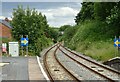
Brimmon Lane, Newtown
This is the northern end of the lane which leads to Treowen Primary School.
Image: © Jaggery
Taken: 23 Jun 2013
0.01 miles
5
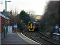
Train departing from Newtown
Heading for Shrewsbury.
Image: © John Lucas
Taken: 11 Jan 2017
0.02 miles
6
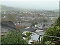
Royal Welsh Warehouse viewed from Barn Lane
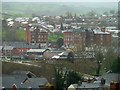
The two large Victorian buildings in the centre of the photo are Agricultural House http://www.coflein.gov.uk/en/site/32018/details/AGRICULTURE+HOUSE%3BPRYCE+JONES+FACTORY/ and the Royal Welsh Warehouse http://www.coflein.gov.uk/en/site/32049/details/ROYAL+WELSH+WAREHOUSE%2C+OLD+KERRY+ROAD%2C+NEWTOWN%3BPRYCE+JONES+WAREHOUSE%2C+OLD+KERRY+ROAD%2C+NEWTOWN/ , both were built for the Pryce Jones mail-order business in the 19th century and are sited very close to the railway station.
Behind these buildings lies the 1970s built 'new town' of Treowen. Between the Royal Welsh Warehouse and the camera is the McDonald's Restaurant and drive-thru (with pyramidal roof) which stands close to the River Severn on the site of a large laundry. There is a glimpse of the river to the right and the Cambrian Bridge stretches across it just in front of McDonald's.
Image: © Penny Mayes
Taken: 25 Dec 2015
0.02 miles
7
Royal Welsh Warehouse viewed from Barn Lane
The two large Victorian buildings in the centre of the photo are Agricultural House http://www.coflein.gov.uk/en/site/32018/details/AGRICULTURE+HOUSE%3BPRYCE+JONES+FACTORY/ and the Royal Welsh Warehouse http://www.coflein.gov.uk/en/site/32049/details/ROYAL+WELSH+WAREHOUSE%2C+OLD+KERRY+ROAD%2C+NEWTOWN%3BPRYCE+JONES+WAREHOUSE%2C+OLD+KERRY+ROAD%2C+NEWTOWN/ , both were built for the Pryce Jones mail-order business in the 19th century and are sited very close to the railway station.
Behind these buildings lies part of the 1970s built 'new town' of Treowen. Between the Royal Welsh Warehouse and the camera is the McDonald's Restaurant and drive-thru (with pyramidal roof) which stands close to the River Severn on the site of a large laundry. The Cambrian Bridge stretches across the river just in front of McDonald's.
Image: © Penny Mayes
Taken: 25 Dec 2015
0.02 miles
8
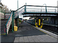
A train for Birmingham departing from Newtown
Image: © John Lucas
Taken: 11 Jan 2017
0.02 miles
9
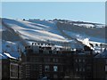
The Royal Welsh Warehouse
With the snowy Kerry hills in the background.
Image: © Penny Mayes
Taken: 28 Nov 2010
0.03 miles
10
Newtown Railway Station
The Cambrian Line towards Shrewsbury.
Image: © JThomas
Taken: 2 Jul 2024
0.03 miles