IMAGES TAKEN NEAR TO
New Road, NEWTOWN, SY16 1BD
Introduction
This page details the photographs taken nearby to New Road, SY16 1BD by members of the Geograph project.
The Geograph project started in 2005 with the aim of publishing, organising and preserving representative images for every square kilometre of Great Britain, Ireland and the Isle of Man.

There are currently over 7.5m images from over14,400 individuals and you can help contribute to the project by visiting https://www.geograph.org.uk
Image Map
Images are licensed for reuse under creativecommons.org/licenses/by-sa/2.0
Notes
- Clicking on the map will re-center to the selected point.
- The higher the marker number, the further away the image location is from the centre of the postcode.
Image Listing (630 Images Found)
Images are licensed for reuse under creativecommons.org/licenses/by-sa/2.0
Image
Details
Distance
1
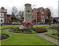
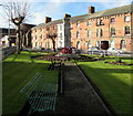
Newtown (Powys) War Memorial
In a grass triangle between New Road and Shortbridge Street.
Image: © Jaggery
Taken: 1 Feb 2017
0.01 miles
2
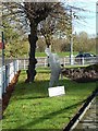
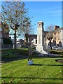
Silent soldier at Newtown Cenotaph
The Cenotaph stands in a small garden edged with pollarded lime trees, apparently named Clifton Park, at the junction of Short Bridge Street with New Road and Old Kerry Road. It was unveiled on January 18, 1925. For the centenary year it is guarded by two silent soldier silhouettes.
Image: © Penny Mayes
Taken: 2 Nov 2018
0.02 miles
3
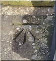
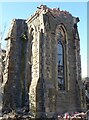
Ordnance Survey Cut Mark
This OS cut mark can be found on the chapel wall on New Road. It marks a point 107.658m above mean sea level.
Image: © Adrian Dust
Taken: 29 Jan 2017
0.02 miles
4
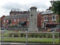
War memorial, Newtown, Powys
Between New Road and Shortbridge Street.
Image: © Christine Johnstone
Taken: 29 Jun 2015
0.02 miles
5
Benches near the War Memorial, Newtown (Powys)
In a grass triangle between New Road and Shortbridge Street.
Image: © Jaggery
Taken: 1 Feb 2017
0.02 miles
6
Newtown Cenotaph
The Cenotaph stands in a small garden edged with pollarded lime trees, apparently named Clifton Park, at the junction of Short Bridge Street with New Road and Old Kerry Road. It was unveiled on January 18, 1925. For the centenary year it is guarded by two silent soldier silhouettes.
Image: © Penny Mayes
Taken: 2 Nov 2018
0.02 miles
7
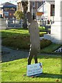
Silent soldier by Newtown Cenotaph
The Cenotaph stands in a small garden edged with pollarded lime trees, apparently named Clifton Park, at the junction of Short Bridge Street with New Road and Old Kerry Road. It was unveiled on January 18, 1925. For the centenary year it is guarded by two silent soldier silhouettes.
Image: © Penny Mayes
Taken: 2 Nov 2018
0.02 miles
8

Bethel Chapel, New Road, Newtown, Powys - December 2021
Image: © Penny Mayes
Taken: 19 Dec 2021
0.02 miles
9

Empty car park, Christmas Day
The tower on the left is the former St David's church, now destined to become a play barn. The imposing building just right of centre is the Baptist Church http://www.geograph.org.uk/photo/149093 on New Road. The large tree on the right is Newtown's famous black poplar http://www.geograph.org.uk/photo/2208039. The tree used to stand on an island between the River Severn and the mill leat to the north east. After the town centre was flooded in the 1960s new flood defences were constructed, the river re-routed to follow the course of the mill leat and the old course of the river (seen here to the left of the road way) filled in to become a car park.
Image: © Penny Mayes
Taken: 25 Dec 2010
0.02 miles
10
Bethel Chapel, New Road, Newtown, Powys - December 2021
Image: © Penny Mayes
Taken: 19 Dec 2021
0.03 miles